Isolated storm odds increase Friday
MACON, Georgia (41NBC/WMGT) – The odds for a few pop-up storms in the afternoon and evening will increase as a summer pattern takes hold across Middle Georgia.
This Evening
Today has been the warmest day of the week with most of the region eclipsing 80 degrees. The scattered cumulus from the afternoon should largely clear out as the sun sets giving way to a mostly clear night. Expect low temperatures in the upper 50s and lower 60s across the region as the wind shifts back to out of the south-southeast around 5 mph. A shower is possible overnight however the odds are against it. As has been the case the past few nights however fog is likely leading into Friday morning.
Tomorrow
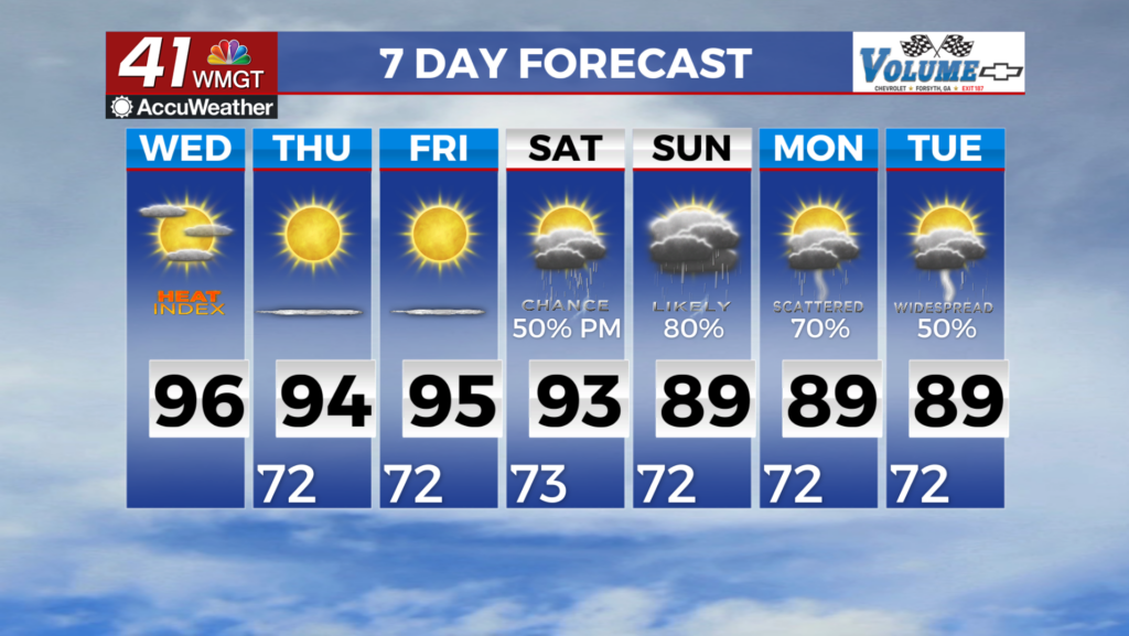
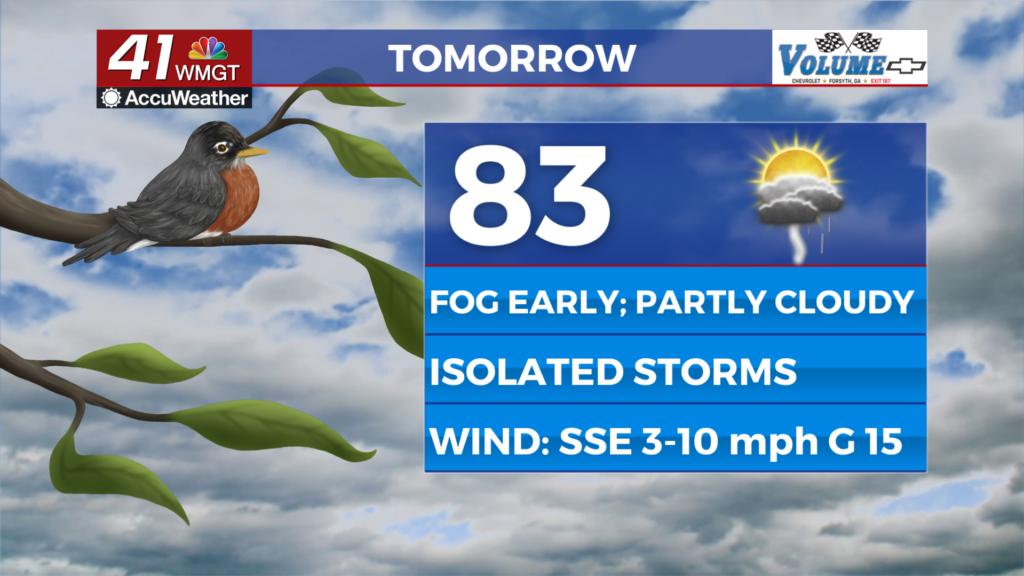
Friday should be the warmest day of the work week with highs likely to climb into the mid 80s for a good chunk of the region. The wind will remain out of the south-southeast at around 5-10 mph. Scattered cumulus clouds are likely in the afternoon and should be accompanied by a few isolated thunderstorms/showers. Rain will remain possible through the evening hours. No severe weather is expected with any storm activity.


Partly cloudy skies are likely overnight with low temperatures largely in the lower 60s. The wind will continue to flow from the south-southeast around 5 mph. A shower or two will be possible early on and fog is likely heading into the start of Saturday.
This Weekend
Saturday is likely to be a partly sunny day with a few isolated storms possible. Afternoon highs should reach the mid to upper 80s, bringing a taste of late spring/early summer. Sunday will see a lot more clouds, however, as a slow moving front that has been progressing across the eastern half of the US since Thursday evening will finally arrive. This should bring on an increased chance for showers and storms as well. Severe weather looks unlikely as this front passes at this time. Temperatures are expected to remain well above average into next week.

Follow Chief Meteorologist Aaron Lowery on Facebook (Aaron Lowery 41NBC) and X (@ALowWX) for weather updates throughout the day. Also, you can watch his forecasts Monday through Friday on 41NBC News at 4, 5, 5:30, 6, and 11 p.m.