Showers and storms kick off Thursday in Middle Georgia
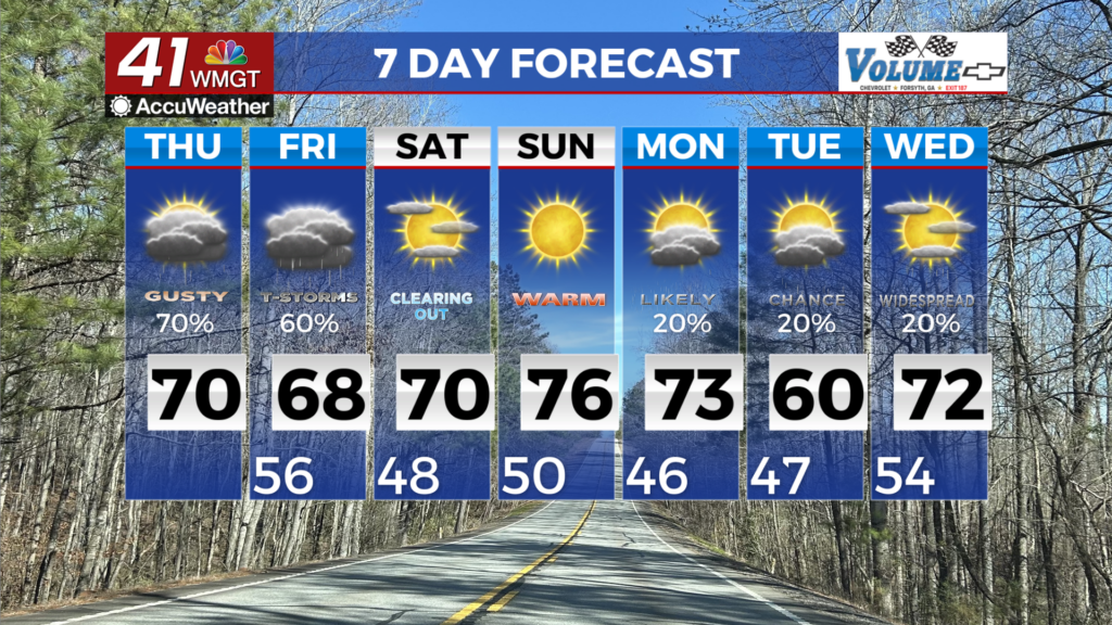
MACON, Georgia (41NBC/WMGT) – Showers and thunderstorms will occur today as a cold front and several weak shortwaves try to generate lift. While enough instability should exist for storms, 


mild temperatures and cloudy conditions should limit updraft strength. The main threat associated with any stronger storms would be wind gusts in the 30-45 mph range. Thunderstorm timing is challenging to narrow down as the front progresses slowly and diurnal heating will be dampened by cloud cover. For Macon and Columbus, the storm window is closer to 5 PM to 11 PM. By Friday morning, rain amounts of 0.40 to 0.80 inches are possible in North Georgia, with 0.70 to 2.00 inches possible in Middle Georgia. The front should stall over southern Georgia and northern Florida on Friday. This will allow ample cloud cover and a few light showers to continue in Middle Georgia. The front’s position to our south should keep the atmosphere stable and prevent any thunderstorms. Since the airmass behind the front will be nearly identical to the one ahead of it, temperatures should top out in the 60s on Friday. Rain showers may linger across portions of Central Georgia Friday night into early Saturday. Exactly where and how long the activity lingers will be dependent upon the location of the surface boundary. By midday Saturday, skies begin to clear as high pressure moves back into the region. Mostly dry and mild temperatures are expected through the weekend. Temperatures will climb into the upper 60s to mid 70s each afternoon and lower to the upper 40s to low 50s each night.