
Thunderstorm odds climb as the work week comes to an end
MACON, Georgia (41NBC/WMGT) – A pair of cold fronts will bring opportunities for thunderstorms to Middle Georgia both Friday and Saturday.
This Evening
While this morning had plenty of clouds things have been clearing for many around Middle Georgia late this afternoon. A few isolated showers are ongoing over the southern half of the region and more will be possible overnight. Cloud cover will thicken again through the overnight hours and into Friday morning. The wind will be quite pronounced tonight from the south-southwest at 10-15 mph with gusts pushing around 20 mph. Low temperatures will be more than 20 degrees above the average with most expected to valley in the mid to upper 60s.
Tomorrow
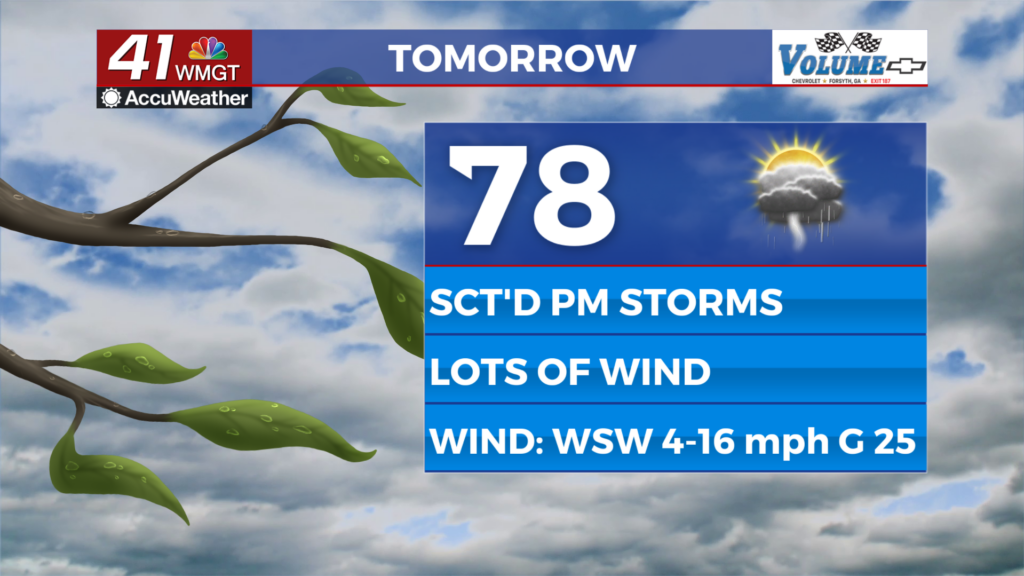
Partly to mostly cloudy skies are likely in the afternoon following a cloudy start to the day. Temperatures should climb into the upper 70s and lower 80s for afternoon highs as the wind flows from the west-southwest at 10-15 mph. Gusts will likely range anywhere from 20-30 mph.


A mix of showers and a few thunderstorms will be possible over the back half of the day as the first of two cold fronts passes through Middle Georgia. At this time no severe weather is expected in Middle Georgia for Friday; the Storm Prediction Center (SPC) did highlight parts of North Georgia for a Level 1 “Marginal” risk for Friday morning/early afternoon, however.


A couple of lingering showers will be possible early Friday night before things go into a bit of a lull before Saturday morning. Some showers will be possible as the sun rises on Saturday, however. Expect low temperatures in the low to mid 60s for most of the region accompanied by shifting winds at 5-10 mph. Skies will be mostly cloudy to overcast.
This Weekend
Saturday will see the second of the two cold fronts pass through Middle Georgia in the afternoon and evening. Leading up to that temperatures will climb into the mid 70s (and possibly the lower 80s in the warmest spots) along with plenty of wind from the southwest (sustained 10-17 mph gusting 20-30ish mph). Storm odds will climb in the afternoon and evening when the front arrives. At this time the SPC has highlighted all of Middle Georgia in a Level 1 “Marginal” threat for severe weather for Saturday afternoon. It is not impossible for parts of the region to be upgraded to a Level 2 “Slight” risk by the time Saturday arrives. While damaging winds will be the main threat a couple of tornadoes and hail do look possible as well.

The frontal passage will lead to clearing overnight and cooler conditions by Sunday morning. The back half of the weekend will feature plenty of sun and wind with highs only reaching the upper 50s and lower 60s. Expect wind gusts Sunday afternoon to range from 25-40 mph. Strong winds are expected again on Monday as the sunshine carries into the new week.

Follow Chief Meteorologist Aaron Lowery on Facebook (Aaron Lowery 41NBC) and X (@ALowWX) for weather updates throughout the day. Also, you can watch his forecasts Monday through Friday on 41NBC News at 4, 5, 5:30, 6, and 11 p.m.