Rain chances gradually increase after today for Middle Georgia
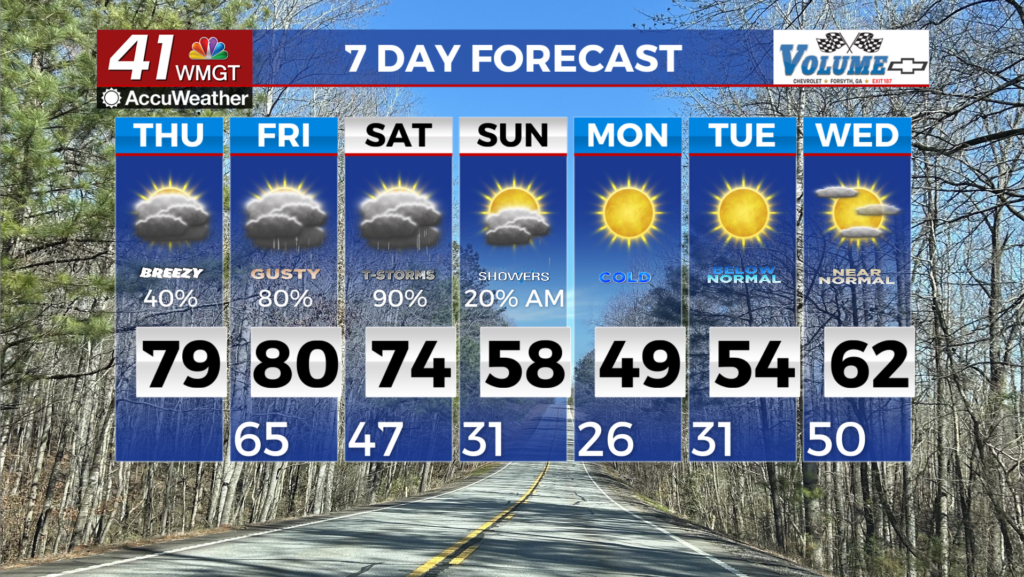
MACON, Georgia (41NBC/WMGT) – Similar conditions today as yesterday with patchy areas of drizzle this morning, temporarily impacting visibility in some areas. We could see a few isolated 


showers early this afternoon which could be convective in nature. Rain chances decrease through the afternoon as winds pick up from the southwest. Moisture increases and high temps today and Friday may reach record levels. Winds today and tomorrow may become gusty during the afternoon up to 20 to 25 mph. Our next opportunity for precipitation comes on Friday with a so-called dryline. Dewpoints to the south of this feature will sit at a very juicy 60-65 degrees while to the north they will sink into the upper 30s and low 40s. This should be enough to bring showers and even a few rumbles of thunder to the area early Friday morning into the afternoon. Timing will be key with this front, as the estimated time of arrival for Middle Georgia is the early morning hours. This dryline feature should stall as it approaches Middle Georgia so this should reduce thunderstorm potential further south on Friday. Saturday will be the main focus with the front likely stalled between Macon and Atlanta, leaning closer to Macon. This front will be the main axis for our weather on Saturday with the potential for impactful weather to shape up into the afternoon. We are looking first at the potential for severe weather. Currently the outlook is for general thunder but this could be increasing Saturday. We have seen an uptick in instability with models. So we are keeping an eye on this. Current forecasted dewpoints have this area in the mid 60s which would be enough for this time of year to support some form of low severe risk. In summary, there is a low but not zero severe threat on Saturday that we will continue to monitor with the potential for higher rainfall totals. Pushing into Sunday, an area of high pressure moves into the area, escorting the front out of the area resulting in dry air and noticeably colder temperatures into Monday. Temperatures into next week will be 15-20 degrees below normal with temps in the mid 20s to low 30s for lows and 40s to 50s for highs.