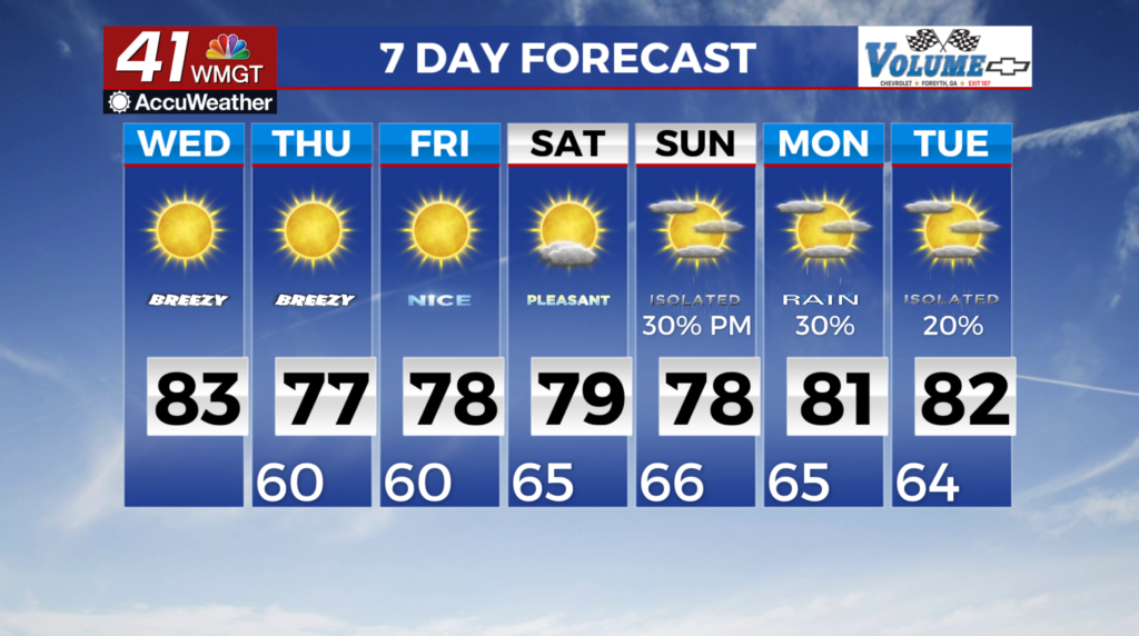
Breezy winds leads to Fall-like conditions through the weekend
MACON, Georgia (41NBC/WMGT) – Dry and pleasant conditions through the short term forecast as an upper level ridge over the Midwest drops across the region and high pressure expands 


 along the East Coast. The breezy low to mid-level northeast flow created by these features will gradually drive out any moisture, resulting in mostly clear skies. High temperatures today will take advantage of the clearer skies and lingering warm airmass, reaching the low to mid 80s. On Thursday, our friends in north and Middle Georgia clamoring for Fall-like conditions will finally be rewarded (for at least a few days) as dewpoints plummet to the low 50s and temperatures return to normal for this time of the year. Highs will be in the mid to upper 70s across much of the area, with upper 60s to low 70s in the higher terrain of north Georgia. Overnight lows will be in the low 60s and upper 50s with no threat of afternoon thunderstorms to ruin your plans. High pressure will keep conditions nice and dry through Saturday. The models begin to really struggle come Sunday. The general consensus that a tropical wave of some kind will bring a moisture return to parts of north and Central Georgia. The GFS model keeps a pretty tight lid on the amount of moisture we would get, however, the European model is a different story indicating a substantial amount of rain is possible as a system forms off the coast of Florida. There is still plenty of time for these two models to make up their minds and come to some kind of agreement, as we will continue to monitor the possibilities as we get closer to the weekend.