Storms possible overnight; more heat tomorrow
MACON, Georgia (41NBC/WMGT) – An incoming cold front could bring a few storms to Middle Georgia ahead of the sunrise Wednesday.
This Evening


A mostly sunny and hot afternoon will stay mostly clear while the sun is out. Clouds will begin to move in during the late evening and overnight hours. It has been a pretty breezy day as well, and that trend will continue into the overnight hours. Expect gusts to push around 20 mph from the southwest. Temperatures will be quite warm tonight as many lows will hover around the 70 degree mark.


In terms of storms, nothing is expected before midnight. The northern third of Middle Georgia falls into a Level 1 “Marginal” risk for severe storms. These storms are expected to be pretty intense as they move into Georgia this evening, however a weakening trend is expected into the night, and by the time they arrive in Middle Georgia they likely won’t have a whole lot of steam left. A few wind gusts or perhaps some will be the main hazards.
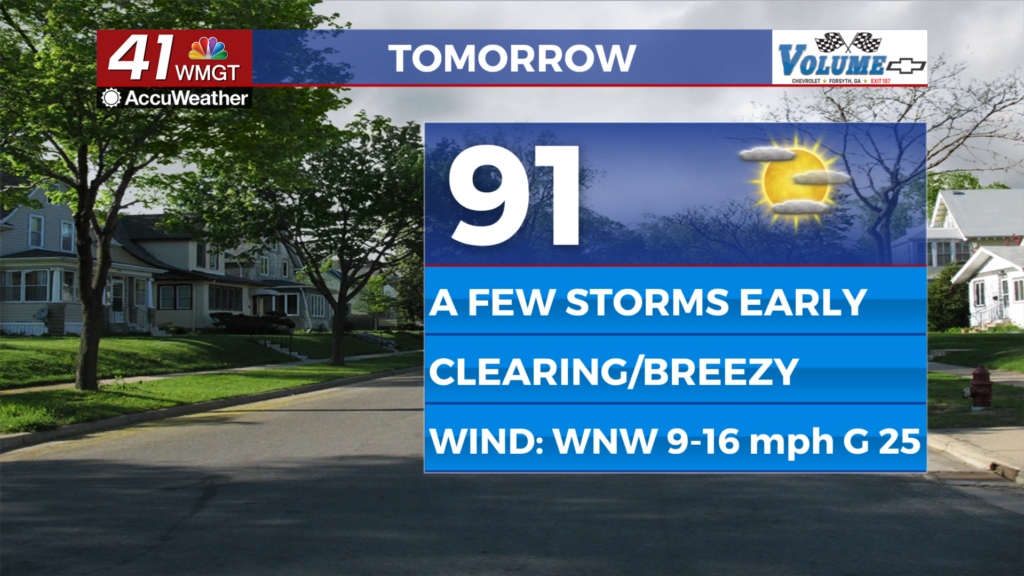
Tomorrow


A few storms or showers may be ongoing over parts of Middle Georgia during the sunrise hours. These should dissipate pretty quickly, and clouds will work to clear out through the late morning and into the afternoon. While storm initiation is expected in the afternoon from the cold front again, that should largely be south of the Middle Georgia region. Expect highs in the upper 80s and lower 90s with ambient wind flowing from the west-northwest at 10-20 mph. Gusts should range between 25 and 30 mph.


Overnight will have a handful of clouds, however humidity should be a bit lower as a result of the cold front Tuesday night. Expect lows in the mid to upper 60s, or about 5 degrees cooler than Tuesday night. Wind will range from 5-10 mph coming out of the northwest.
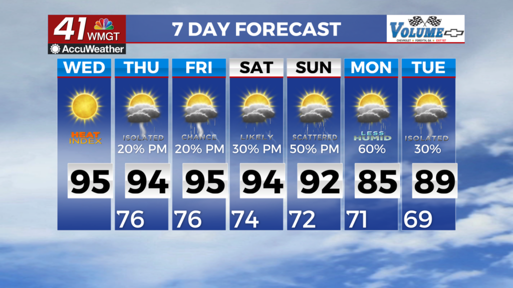
Thursday and Beyond


While Thursday will still feature plenty of heat, things should cool off a bit Friday to end the week as the cold front passage will finally be complete. The relief from the heat will be short lived, however, and conditions should return into the 90s by early next week.

Follow Chief Meteorologist Aaron Lowery on Facebook (Aaron Lowery 41NBC) and Twitter (@ALowWX) for weather updates throughout the day. Also, you can watch his forecasts Monday through Friday on 41NBC News at 4, 5, 5:30, 6, and 11 p.m.