Another round of rain expected tonight; more tomorrow
MACON, Georgia (41NBC/WMGT) –
This Evening and Overnight


A cloudy but mostly dry afternoon will see another round of rain arrive after the sunset tonight. This rain should be off and on through the overnight hours and into Thursday morning. It will be calm and muggy with lows expected in the lower 60s across the region. Wind will be light out of the west-southwest.
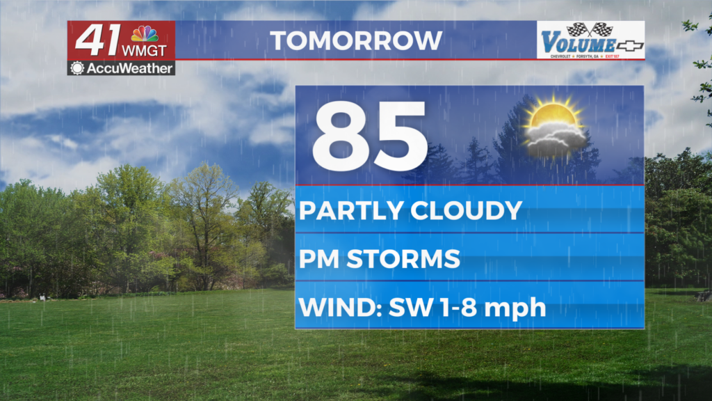
Tomorrow


Rain will likely be ongoing for some around Middle Georgia as the sun rises Thursday. Expect a partly cloudy day with some isolated to scattered storms in the afternoon. Temperatures will peak in the mid 80s for most of the region. Wind will flow from the west-southwest at around 5-10 mph.


As for the storms, a Level 1 “Marginal” risk for severe weather includes the entirety of Middle Georgia. While overall organized storms are not expected, some small hail and a few strong wind gusts will be the primary hazards.


Overnight will be muggy and scattered storms will remain a possibility. Lows will be in the low to mid 60s with wind staying from the south-southwest at around 5 mph.
Friday and Beyond


A cold front will move through on Friday, bringing another round of storms with it. A Level 1 “Marginal” threat includes the entire region again. While the above mentioned hazards for Thursday will also be possible, a brief tornado could also end up in the mix on Friday. This weekend looks to continue the soggy pattern as Friday’s cold front stalls out and becomes stationary, keeping the wet conditions over the Peach State through Mother’s Day.

Follow Chief Meteorologist Aaron Lowery on Facebook (Aaron Lowery 41NBC) and Twitter (@ALowWX) for weather updates throughout the day. Also, you can watch his forecasts Monday through Friday on 41NBC News at 4, 5, 5:30, 6, and 11 p.m.


