Temperatures rebound Tuesday
MACON, Georgia (41NBC/WMGT) – Following a couple of cooler days temperatures will be back in the 70s Tuesday afternoon.
This Evening


A mostly sunny afternoon will become a partly cloudy night as cirrus clouds will linger across the region. While another chilly night is expected, it will not be below freezing this time. Lower 40s and upper 30s are expected for temperature valleys across Middle Georgia. Wind will flow from the southeast at around 5-10 mph.
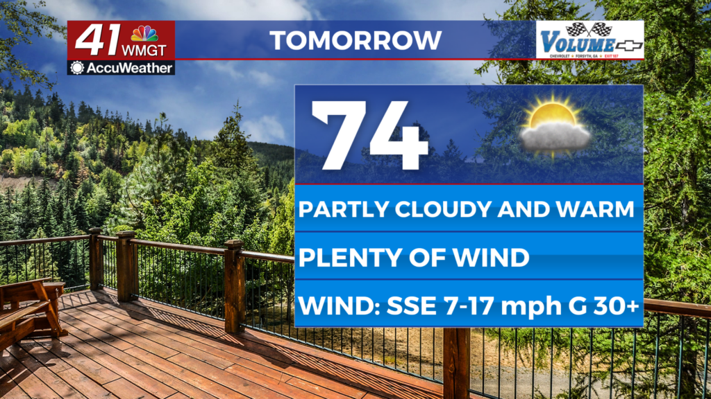
Tomorrow


Temperatures will be back into the 70s Tuesday afternoon with most spots reaching the low to mid 70s. Wind will be quite noticeable from the south-southeast as sustained speeds range from 7-17 mph, potentially gusting over 30 mph. Overhead skies will be partly cloudy. More clouds are anticipated in the later evening hours.


Overnight is when things get interesting as a cold front will arrive ahead of the sunrise on Wednesday. These storms will bring even more wind than what is already occurring across the region (which is more than plenty). This could lead to some damage thanks to trees or other things being blown over. Rain will also be heavy as the storms roll in. Most of Middle Georgia falls into a Level 1 “Marginal” risk for severe weather, however the far southeastern reaches are included in a Level 2 “Slight” risk for early Wednesday. As mentioned above the primary risk will be straight line winds, however a brief spin up tornado cannot be ruled out.


Aside from storms the wind will still be plenty strong as it flows from the south at 15-30 mph and could gust over 40 mph. Skies will be mostly cloudy and the storms should begin to arrive between 3 and 5 am. Low temperatures will likely be around or before midnight in the upper 50s and lower 60s.
Wednesday and Beyond


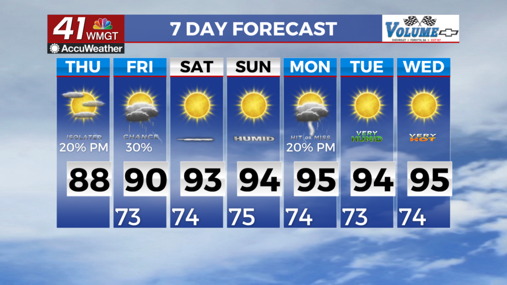
Following the storms in the morning clouds will work to clear out in the afternoon. Highs will reach the mid to upper 70s on the back side of the cold front. Wind will remain strong from the west-southwest at 10-25 mph. Gusts will likely range from 30-40 mph. All that wind will lead to temperatures dropping into the 30s again ahead of Thursday morning. Highs Thursday will also be cooler as a result of the frontal passage.

Follow Chief Meteorologist Aaron Lowery on Facebook (Aaron Lowery 41NBC) and Twitter (@ALowWX) for weather updates throughout the day. Also, you can watch his forecasts Monday through Friday on 41NBC News at 4, 5, 5:30, 6, and 11 p.m.


