
Warming trend continues Thursday
High pressure has slowly started to move east of the area today allowing a little more moisture and humidity to move back into Middle Georgia.
As this happens, we could see a few more clouds move into the area, but any rain should hold off until the weekend.
High temperatures will slowly warm into the mid and upper 70’s through the rest of the week.

We are closely watching Tropical Depression Eta tonight as it moves through parts of Central America and eventually moves back into the Caribbean.
Eta is forecast to quickly strengthen back to a tropical storm by the weekend and head north. At that point we could see some impacts in south Florida.
The NHC has forecast Eta to move into the Gulf of Mexico, but after that there are still a lot of questions.
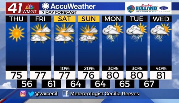
Eta might not have a direct impact on Middle GA (or it might), but we will see increasing rain chances next week.
We will also see more tropical moisture in the area until a cold front moves through late next week.
Buckle up, because we still have a month left in hurricane season, and the activity doesn’t seem to be slowing down.

Leave a Reply