Thunderstorms likely tonight, some could be strong/severe
MACON, Georgia (41NBC/WMGT) – An incoming storm system will bring thunderstorms tonight and tomorrow morning, some of which may be severe.
This Evening and Tonight


Cloud cover will remain abundant around Middle Georgia this evening ahead of the overnight rain. Conditions will remain muggy with temperatures in the 70s and dew points in the mid 60s are likely much of this evening and into tonight. Temperatures will only bottom out in the mid to upper 60s. Ambient winds will be rather strong out of the south-southeast at 10-25 mph. Gusts could reach as high as 40 mph.


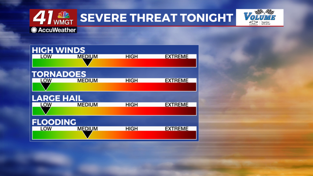
As for the overnight storms, a Level 1 “Marginal” risk for severe weather exists for the western 2/3 of the region until 5 am tomorrow morning. Heavy rain cold lead to some flooding, and an Areal Flood Watch is in effect for several Georgia Counties until 8:00 tomorrow morning as a result. Strong winds will also be a decent threat. A brief spin up tornado cannot be ruled out, but the odds will be overall low for that or hail tonight.
Tomorrow


Storms will be ongoing at the onset of the sunrise. A Level 2 “Slight” risk includes the southeasternmost counties of Middle Georgia for late tomorrow morning. The rest of the area where storms will be ongoing will fall into the Level 1 “Marginal” risk zone. The tornado risk will be slightly higher late tomorrow as storms will be able to organize a bit more as the sun rises, however they will likely be getting ready to clear the region as they fully gain organization. Storms will likely delay the start of the Masters in Augusta as well.


Following the morning storms clouds will try to clear out some in the afternoon and evening as temperatures reach the upper 70s. Winds will remain strong from the southwest at 10-25 mph, gusting as high as 35-40 mph. A stray shower or two will be possible in the late afternoon or evening, but those will be short lived.


Overnight the winds will be westerly at about 10-20 mph (G 30-35 mph) as remaining clouds work to clear out. Temperatures will bottom out in the low to mid 50s.
Friday and Beyond


Sun and wind will stay with Middle Georgia all day Friday as temperatures peak in the lower 70s around the region. We will see that wind calm Saturday as the sun sticks around, leading to much warmer conditions over the weekend.

Follow Meteorologist Aaron Lowery on Facebook (Aaron Lowery 41NBC) and Twitter (@ALowWX) for weather updates throughout the day. Also, you can watch his forecasts Monday through Friday on 41NBC News at 4, 5, 5:30, 6, and 11 p.m.