Winds slow some Friday as sun sticks around
MACON, Georgia (41NBC/WMGT) – Winds won’t be as strong Friday afternoon as sunshine dominates the sky.
The Rest of the Evening


Some scattered cumulus clouds have begun to move into the northern counties of Middle Georgia. These will carry into tonight, however they should clear after midnight. Winds will slow to 5-12 mph from the northwest, however gusts could still push 17 mph. Low temperatures will largely drop into the low 40s, however a couple of upper 30s cannot be ruled out.
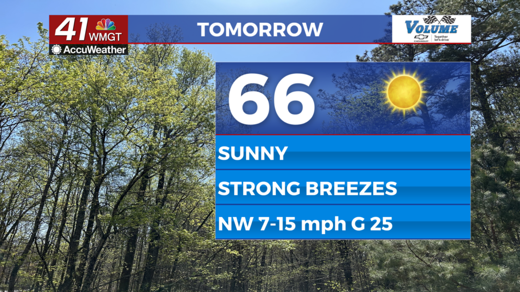
Tomorrow


It will be a cool sunny day by April standards as temperatures top off in the mid to upper 60s. Skies will likely remain cloudless for most of Middle Georgia throughout the day. Ambient winds will still be somewhat strong at 7-15 mph from the northwest, gusting as high as 25 mph. That is a solid notch down from Thursday afternoon which was filled with gusts well over 30 mph. Pollen levels will also remain low for another afternoon before climbing this weekend.


Overnight skies will be clear as winds slow and shift more towards the north-northwest. Low temperatures will be in the upper 30s and lower 40s rolling into Saturday morning.
The Weekend and Beyond


Saturday will be mostly sunny with a lot of cirrus clouds expected in the afternoon and evening. Highs will reach the upper 60s and lower 70s with ambient winds from the north-northwest likely to range from 5-10 mph. Overnight lows will drop into the upper 30s and lower 40s.

Sunday a warm front will bring a bit more cloud cover in the afternoon as well as highs in the mid 70s for most of the region. This will also shift the wind to the south-southeast heading into the overnight hours and Monday. Monday will see highs return to the 80s, and cloud cover will ramp up more next week as well.

Follow Meteorologist Aaron Lowery on Facebook (Aaron Lowery 41NBC) and Twitter (@ALowWX) for weather updates throughout the day. Also, you can watch his forecasts Monday through Friday on 41NBC News at 4, 5, 5:30, 6, and 11 p.m.