More pleasant weather Wednedsay
MACON, Georgia (41NBC/WMGT) – High pressure will keep calm winds and mostly sunny skies over much of Georgia Wednesday.
This Evening


Scattered clouds from this afternoon will work to clear out as the night draws on. Winds will remain light from the east-northeast tonight as temperatures plummet towards the freezing point.
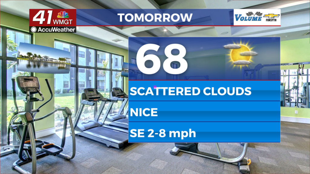
Tomorrow


Some scattered cirrus clouds will likely move in during the afternoon, but for the most part Wednesday will be a sunny day. Temperatures will mainly reach the mid to upper 60s as the wind comes in from the south-southeast around 5 mph.


Tomorrow night that wind will come from the south with the same speed as temperatures drop into the mid to upper 30s. Some scattered cirrus clouds will likely hang around much of the night, however things should be mostly clear by Thursday morning.
Thursday and Beyond


Sunny skies early will give way to scattered cloud cover in the afternoon. Winds will come from the south-southwest at 10-15 mph, gusting over 20 mph. High temperatures will reach the upper 60s and lower 70s around Middle Georgia as cloud cover thickens more in the later afternoon and evening. An isolated shower or two will be possible in the northern counties ahead of sunset.


Overnight a cold front will bring scattered showers to most of Middle Georgia. This will clear the northern counties ahead of the sunrise on Friday, and should clear the southern counties ahead of lunchtime Friday. Skies will clear out Friday afternoon before scattered clouds return Saturday. While this weekend looks to be dry, powerful winds are expected Saturday afternoon as a 2nd cold front passes through the state. Sunday will see calmer conditions.

Follow Meteorologist Aaron Lowery on Facebook (Aaron Lowery 41NBC) and Twitter (@ALowWX) for weather updates throughout the day. Also, you can watch his forecasts Monday through Friday on 41NBC News at 4, 5, 5:30, 6, and 11 p.m.