


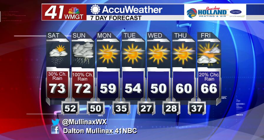
Rain chances increase towards end of week
MACON, Georgia. (41NBC/WMGT) – A few light rain showers will move out of our area this morning leading to clearing conditions this afternoon.
TODAY.
A few areas around Middle Georgia have reported snow flurries this morning, but with ground temperatures above freezing we will not see any accumulations. Temperatures will continue to run well below average this afternoon as daytime high temperatures will top out in the lower 50’s. The average high temperature for this time of year is 67° so we will fall well short of that mark this afternoon. Under a mostly sunny sky we will be breezy as well. A northwest wind will continue to bring in drier and cooler air today. Wind gusts this afternoon will top out near twenty miles per hour at times. Overnight tonight we are going to see one of our coldest nights since January. Air temperatures will be in the mid to upper 20’s, but with a northwest wind at five to ten miles an hour the wind chill factor will be in the upper teens and lower 20’s. Make sure to bring in pets and plants that are sensitive to the frigid temperatures.
TOMORROW.
You could hit the repeat button for the forecast on Wednesday as temperatures will once again be running in the low 50’s during the afternoon hours with a lot of sunshine. The biggest difference is that the wind will lay down tomorrow so it will not feel as cold outside.
REST OF WEEK.
We stay dry through Friday as the high pressure system moves off and zonal flow returns to Middle Georgia. While the weekend will not be a washout, we will be dealing with scattered showers on Friday and Saturday, but widespread showers on Sunday as a cold front moves through our area.
 Follow Meteorologist Dalton Mullinax on Facebook (Dalton Mullinax 41NBC) and Twitter (@MullinaxWX) for weather updates throughout the day. You can also watch his forecasts Monday through Friday on 41NBC News at Daybreak (5-7 a.m.) and 41Today (11 a.m.).
Leave a Reply