Severe storms possible Monday evening
MACON, Georgia (41NBC/WMGT) – A line of thunderstorms will move through Middle Georgia later this evening bringing with it a threat for severe weather.


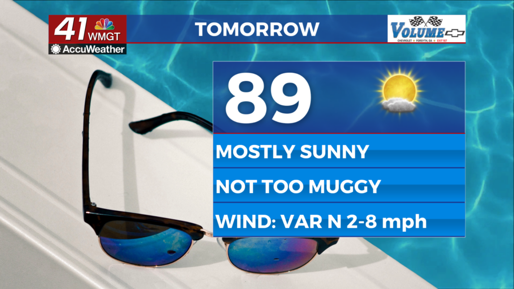
Sunshine will be plentiful for most of the afternoon before any severe weather odds even begin. While an isolated shower/storm will be possible in the afternoon, they will not be tied to the complex of stronger storms (this will still be well off to the north). Temperatures will reach into the mid to upper 90s with heat indexes ranging from 105-111 degrees. Hydration is critical in this heat as well as taking breaks in the shade/AC and wearing light clothing. Sunblock is also necessary with a UV index of 10.7 in Macon this afternoon. A Heat Advisory is in effect until 8:00 PM EDT.
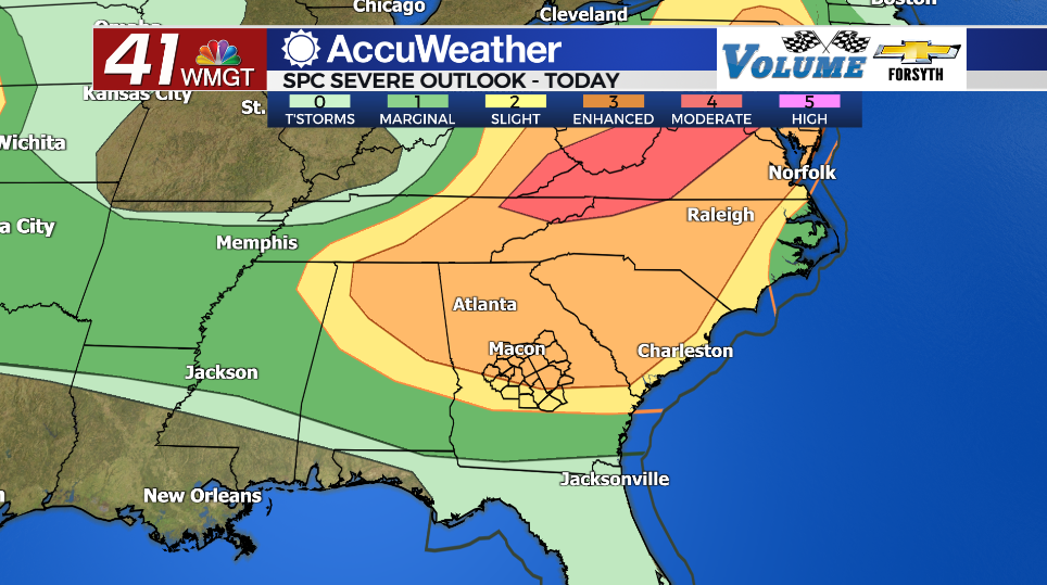
Storms will likely begin to move into the northwestern counties during the suppertime hours, pushing east-southeast throughout the remainder of the evening. The SPC has issued a Level 3 “Enhanced” risk for the northern 2/3 of the region later this evening. The southern 1/3 is under a Level 2 “Slight” risk. Tornadoes are not really of concern this evening, however straight line winds most certainly will be. The line of storms will likely pack sustained gusts of 50ish mph with pockets that push 60-70 mph. A couple of pockets could potentially reach 80 mph.


As mentioned above, the line of storms will arrive heading into suppertime. Given the heavy rain throughout the back half of yesterday for most of the region the soil is likely a bit wet. This could make it easier for winds to uproot some trees. Power outages are unfortunately going to be on the table for much of Middle Georgia this evening as well. It would also be a good idea to avoid travel during the storms as rain will be very heavy with the strong winds, making for very low visibility. It also would not be a bad idea for Middle Georgian’s to have their safe space ready: even though the tornado threat is low, the straight line wind threat will unfortunately pose the risk of trees blowing over onto roofs/roadways.


Storms should subside for most of the region ahead of midnight with partly cloudy skies remaining into Tuesday morning. Some patchy fog will be possible to begin Tuesday with temperatures in the low to mid 70s and dewpoints in the low 70s. An isolated storm or two lingering through the night cannot be ruled out, although it is unlikely anything will be left by sunrise tomorrow.

Follow Meteorologist Aaron Lowery on Facebook (Aaron Lowery 41NBC) and Twitter (@ALowWX) for weather updates throughout the day. Also, you can watch his forecasts Monday through Friday on 41NBC News at Daybreak (5-7 a.m.) and 41Today (11 a.m).