Storm chances climb this evening in Middle Georgia
MACON, Georgia (41NBC/WMGT) – Plenty of cloud cover will fill the Middle Georgia skies before rain moves in later this evening.
Today
Cloud cover began to roll into the northern counties of Middle Georgia well ahead of the sunrise this morning. Rain, however, has only made it into Hancock County thus far, and it was only for a brief moment. Cloud cover will remain plentiful for most of the afternoon, however high temperatures are still expected to reach into the lower 90s with heat indexes into the upper 90s. The UV Index this afternoon will peak at around 8 in Macon, so sunblock is still very much necessary for anyone spending time outdoors.
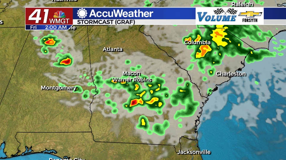
Our first chances for rain this afternoon will likely be rather late and in the form of a few light showers or a thunderstorm. These will develop more as we head into the overnight hours, becoming widespread as we cross into Friday morning. A Level 1 “Marginal” risk for severe weather is in effect for the northwestern half of Middle Georgia. The primary threat with storms will be some strong wind gusts or a little bit of small hail along with frequent lightning. Storms will wane in intensity the deeper into the night we go.


Outside of storms tonight conditions will be overcast with lows in the low to mid 70s. Winds will blow out of the south-southeast at about 5-15 mph, gusting upwards of 20 mph.
Tomorrow and Beyond
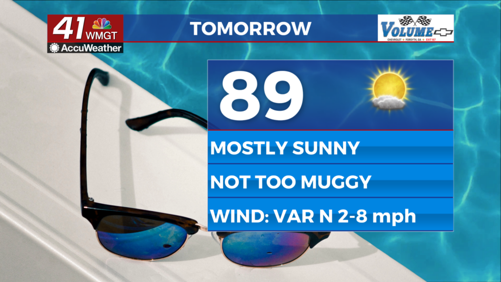
Friday will be off to a wet start as some lingering storms hang around much of Middle Georgia rolling into sunrise. As temperatures begin to rise (highs will reach the upper 80s), storm intensity will too. Model guidance suggests linear development of a MCS tomorrow morning that could occur in the southernmost counties of Middle Georgia. This has been highlighted with a Level 1 “Marginal” risk as well. It is very possible this intensification does not occur until the storms are out of our region, however, which could lead to that risk being dropped.


Storm activity should slow heading into Friday afternoon with some breaking in the cloud cover expected heading into the evening. A small, late round of storms will be possible tomorrow night even after most activity has subsided, however. Temps will drop into the low to mid 70s ahead of Saturday morning with ambient winds from the north-northwest at 5-10 mph.
This weekend will see a drop in rain chances Saturday afternoon before another round of scattered storms moves in late Saturday and into Sunday. Highs will return to the low to mid 90s with lows towards the mid 70s as humidity increases.

Follow Meteorologist Aaron Lowery on Facebook (Aaron Lowery 41NBC) and Twitter (@ALowWX) for weather updates throughout the day. Also, you can watch his forecasts Monday through Friday on 41NBC News at Daybreak (5-7 a.m.) and 41Today (11 a.m).