
An active weather weather pattern starts the new week
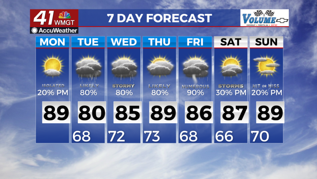
MACON, Georgia (41NBC/WMGT) – Strong storms with gusty winds and heavy rain, passed through Middle Georgia yesterday evening and overnight. For the week ahead, any storms that 


develop, strong to damaging winds will be the primary threat along with frequent lightning and heavy rainfall. Overnight and into Monday morning, things are expected to improve drastically with drier and cooler air working across much of the area. Temperatures should be around 5 degrees cooler with lower humidity as well. Ant additional showers and storms will likely remain south of the area across South Georgia. Broad upper level troughing over the western U.S. will hold generally weak west-to- northwest upper level flow over the region through the upcoming 

week. Surface flow remains more west-to- southwest through the period, holding moisture across the area and delivering several weak shortwaves just to the north. Daily thunderstorm chances will peak above 30 percent for much of the area. The next more notable system is associated with the region off the Texas Gulf. Uncertainty remains high in the development of any system, and any tropical development would influence forecast outcomes, however the moisture associated with this system will definitely be water-loaded. Temperatures through the period will be near normal to slightly cool, due to cloud coverage and continued rain chances. Highs will be in the 80s to low 90s and significant moisture will result in elevated heat indices. Thursday looks to be the warmest day of the period.