Widespread rain arrives tonight, but the weekend looks pretty nice
MACON, Georgia (41NBC/WMGT) – A low pressure system coming up from the gulf will bring rain to the Peach State tonight before conditions work to clear out Saturday.
The Rest of the Evening


Cloud cover will continue to grow around Middle Georgia ahead of tonight’s rain. Winds will become variable overnight after coming from the east most of today. The also will get stronger with gusts between 20-25 mph possible during the heaviest rain tonight.


Light rain will likely move into the western counties ahead of midnight with the heaviest rain likely between 1 am and 5 am around Middle Georgia. Rain totals will likely range from an inch to an inch and a half, but the wettest spots could see more than 2 inches. Overnight low temperatures will range from the lower 40s (northern counties) into the lower 50s (southern counties).
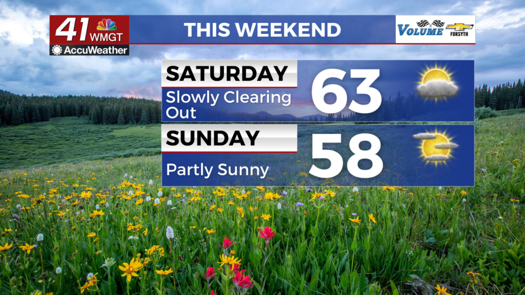
Tomorrow


A couple of small showers will be possible early, but all rain should subside ahead of lunchtime. Highs will largely reach the low to mid 60s around the region with winds from the west coming in at 10-15 mph. Gusts will likely again range from 20-25 mph. Cloud cover will clear over the back half of the day as well.


A few scattered clouds are likely overnight with temperatures dropping into the lower 40s and upper 30s. Winds will come from the west-northwest at about 6-12 mph with gusts pushing upwards of 20 mph.
Sunday and Beyond


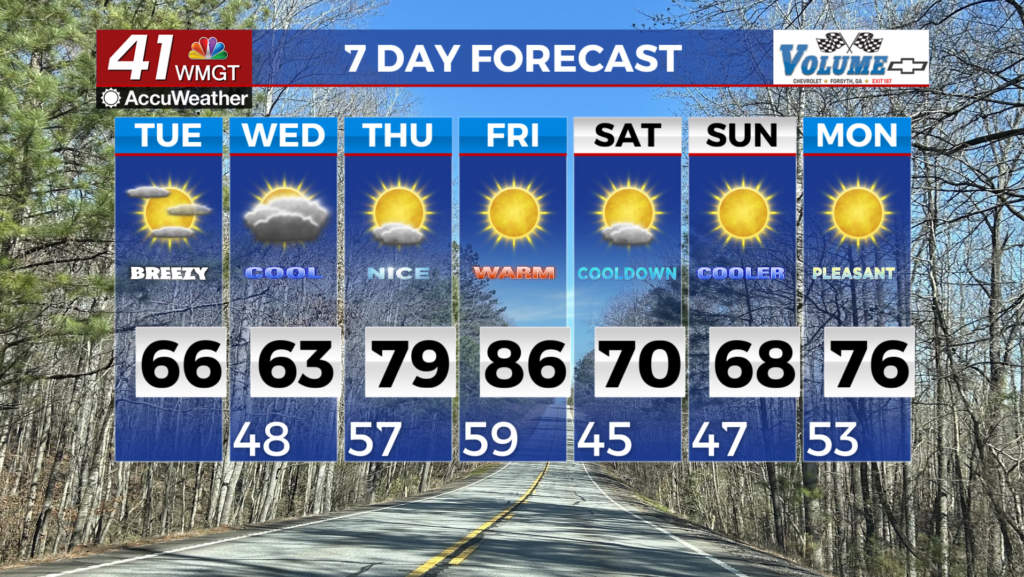
Partly sunny skies are likely Sunday with highs in the upper 50s and lower 60s. Again it will be breezy from the northwest with winds of 5-15 mph likely. Gusts will again range from 20-25 mph through the afternoon. Overnight skies will be partly cloudy with low temperatures dipping towards the freezing point.

Monday will be mostly cloudy with rain moving in during the evening as a warm front passes through. The cold front will arrive Tuesday, bring thunderstorms. Some potentially could be strong to severe. Nicer conditions are expected next Wednesday and Thursday before rain re-enters the forecast again Friday.

Follow Meteorologist Aaron Lowery on Facebook (Aaron Lowery 41NBC) and Twitter (@ALowWX) for weather updates throughout the day. Also, you can watch his forecasts Monday through Friday on 41NBC News at 4, 5, 5:30, 6, and 11 PM.


