Warming up before showers & storms arrive later in the week
MACON, Georgia (41NBC/WMGT) – High pressure is centered off the Mid-Atlantic coast nosing into Georgia and the Carolinas. This ridge is loosing its grip on the region as the center is expected to move further east out to sea. The ridge will keep things dry for now, but with it moving out this allows precipitation to begin moving into North Georgia tonight. The frontal system 


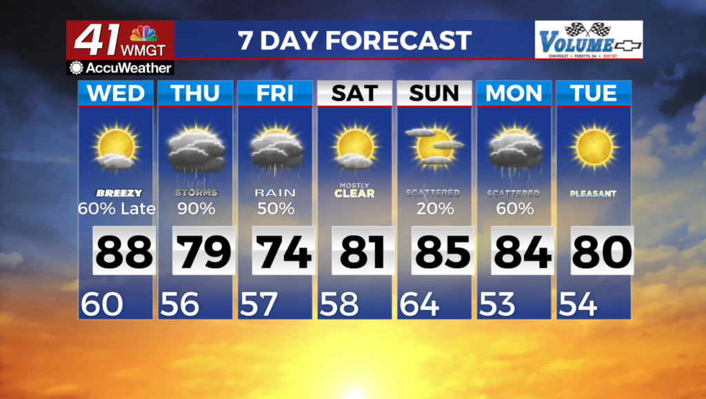
is developing across the Central Plains. The frontal boundary moves across the Southern Great Lakes and into the Ohio Valley through tonight. A closed low center develops along the frontal boundary over Oklahoma and Arkansas this evening which moves rapidly east across Tennessee and Kentucky tonight. This low center pushes some showers and isolated thunderstorms into North Georgia just after midnight. These showers and thunderstorms continue through the day Wednesday with some strong storms expected Wednesday afternoon into the evening hours. The Storm Prediction Center currently has portions of North Georgia under a Marginal Risk of severe storms for Wednesday afternoon/evening. Temperatures Wednesday will get into the 70s and 


80s with lows in the 50s and 60s. The extended forecast kicks off on Thursday with showers and thunderstorms expected. The main concern on Thursday will be heavy rain, which could present some flash flooding problems, especially in Metro Atlanta. Heavy rain primarily along the I-20 corridor on Thursday morning could drop up to two inches of rain in a 12 hour period. While most of the state remains in drought, this much rain over an urban area has the potential to create run-off problems leading to flash flooding issues. As the front sinks south through the day on 


Thursday, it will pull the axis of heaviest rain to the southern part of the coverage area. The threat of severe weather will remain low, as cloud cover limits destabilization across Middle Georgia, however, the possibility of a few strong thunderstorms is certainly possible. Another pulse in the trough may take aim at the area on Saturday, bringing another round of showers and thunderstorms to Middle Georgia, before another stronger low sweeps through the area on Monday bringing back another chance for thunderstorms briefly before high pressure gives us a break by the middle part of the week. Temperatures fall back into the 70s on Thursday where they’ll remain through the rest of the extended forecast. Overnight lows on Thursday into Friday will fall into the 40s.