Warmer temps bring increased rain chances
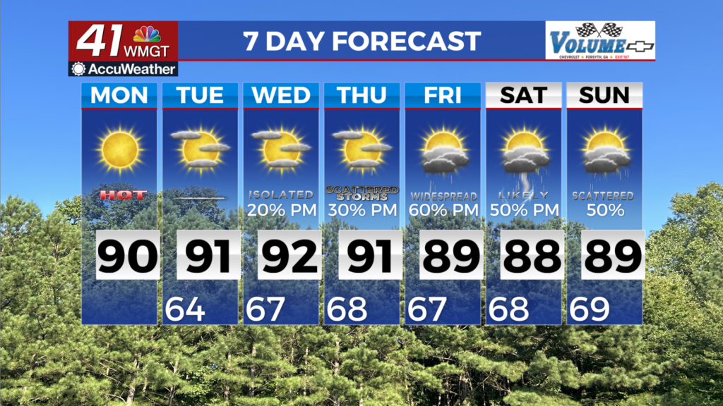
MACON, Georgia (41NBC/WMGT) – Another warm day is expected this afternoon as temperatures rise into the upper 80s and low 90s. The best chance for afternoon thunderstorms has shifted 


to the west, although a few isolated thunderstorms are possible along the Georgia/Alabama border. Coverage seems to be significantly less than Sunday’s storms. The forecast for Tuesday is a carbon copy of today with increasing afternoon clouds out ahead of the cold front that’s expected to bring the next round of weather. Winds will remain southerly at 5 to 10 mph with some higher gusts in the higher elevations of northern Georgia. Overnight lows will be pleasant in the mid 60s. Ridging at the surface and aloft on Tuesday keeps things dry and warm, however the forecast is 


trending more towards an unsettled pattern with more opportunities for rainfall. By Wednesday afternoon and evening, a cold front pushes southeastward towards far North Georgia. The rain chances will be relegated to these areas in proximity to the frontal forcing with drier conditions favored farther southeast. The front makes only limited southward progress by Thursday into North Georgia as upper support departs northeastward from the Great Lakes into Quebec. Diurnally-enhanced chances for rain should be highest along north I-20. Flow aloft then transitions 

into southwest flow by late week as the front becomes stationary. Weak shortwaves within this flow enhances convective coverage headed into the weekend, particularly with the aid of daytime heating. Coverage again will be likely be highest across roughly the northern half of the area through this period. The organized severe threat looks low given the summer-like weak sheared environment, a couple of strong to isolated severe storms can’t be ruled out. While locally heavy rainfall will also be possible, the lack of widespread persistent soaking rain will limit the overall impact on the drought. Temperatures remain generally several degrees above normal (highs in the mid to upper 80s to lower 90s on the warmest days and lows in the 60s), although marginally cooler highs are possible late week given increased clouds and convective coverage.