

Turning up the heat and humidity this weekend
MACON, Georgia (41NBC/WMGT) – The first weekend of June will see a return to more seasonal conditions following a brief midweek cooldown.
This Evening
A mostly sunny evening will become a partly cloudy night as more high level cirrus clouds are likely to move in overhead late this evening and tonight. It will be another below average night with most spots dropping into the lower 60s by Saturday morning. A couple of spots may still drop below 60 degrees. The wind will be light out of the southeast around 5 mph. Patchy fog is possible although unlikely.
Tomorrow
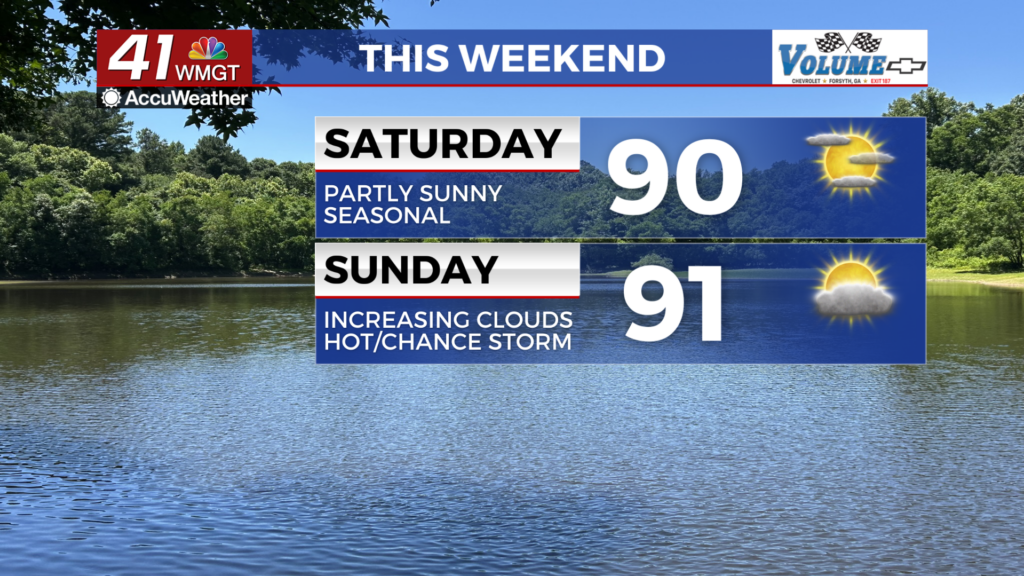
The first half of the weekend will be partly sunny and seasonal with temperatures climbing into the upper 80s and lower 90s. The wind will be light out of the south-southeast around 5-10 mph. Sunscreen is recommended for those spending ample times outdoors as the UV index is expected to be over 10. This translates to less than half an hour before burning begins for those who are unprotected.


Overnight more clouds are likely to fill in with low temperatures climbing closer to average but still staying below it in the mid-upper 60s. The wind will continue out of the south-southeast around 5 mph. The odds for fog will be higher than Friday night/Saturday morning but it should still be patchy in nature.
Sunday and Beyond
Conditions will warm further Sunday with cloud cover filling in throughout the afternoon. A couple of showers or a storm will be possible in the late afternoon and evening, possibly lingering into the early parts of Sunday night. The wind will be light and variable throughout the day and overnight.

Storm odds will be a bit higher early next week thanks to a slow moving front in the area. While this may lead to a slight cooldown Monday and Tuesday summer heat is expected throughout most of next week.

Follow Chief Meteorologist Aaron Lowery on Facebook (Aaron Lowery 41NBC) and X (@ALowWX) for weather updates throughout the day. Also, you can watch his forecasts Monday through Friday on 41NBC News at 4, 5, 5:30, 6, and 11 p.m.