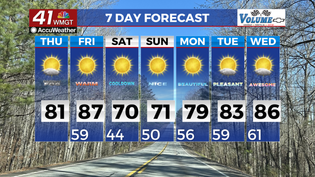
Temperatures to reach their peak for the week as high pressure sticks around
MACON, Georgia (41NBC/WMGT) – Temperatures around Middle Georgia will be the warmest of the week today despite a cold front passing through yesterday.
Today


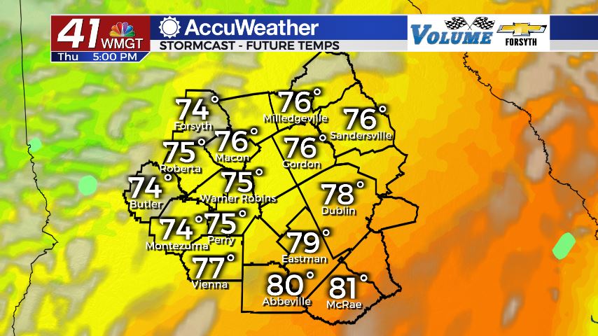
It was another warm and humid morning around Middle Georgia with a few areas of patchy fog. There was limited cloud cover to begin the day as well with most of them being upper level cirrus clouds. Today is going to be very similar to Tuesday where we will see mostly clear skies carry into the lunchtime hours before cloud fields begin to develop later due to surface heating. Highs across Middle Georgia should all be in the lower and mid 80s today as winds come in from the south-southwest at 5-10 mph. Gusts could reach upwards of 20 mph at times, but for the most part should remain below 15. Rain is not expected in any capacity today.


During the early overnight hours the clouds that formed in the afternoon should begin to dissipate, giving us mostly clear skies heading into tomorrow morning. Winds overnight will blow from the southwest at 5-10 mph as low temperatures also reach their peaks for the week. The majority of the region will see lows in the lower 60s, but a few spots could cool down to about 57.
Tomorrow


Cloud cover will begin to fill in during the sunrise hours as a cold front will arrive in the middle of the day, very similar to Wednesday. In fact, this may as well be a repeat of Wednesday as the front will again greatly weaken on its way here, resulting in a few isolated showers in the northern half of the region. The southern counties should continue to see mostly sunny skies, and the northern counties will join them during the later afternoon hours. Winds will blow in from the west-northwest at 10-15 mph as the front arrives with gusts upwards of 25 mph. This will keep temperatures a bit cooler, resulting in highs in the upper 70s for most of the region with a few spots still getting over 80.


Overnight skies will remain partly cloudy as temperatures actually cool off some, bottoming out in the mid 40s all the way up to the lower 50s. Winds overnight will blow in from the north-northwest at about 5-10 mph. bringing in a bit of cool and dry air, even if it’s only briefly.
The Weekend


Saturday will see a mix of sun and clouds in the afternoon as highs reach the upper 60s and lower 70s. Winds will come in from the north-northeast at 5-10 mph as cloud cover further increases during the afternoon. Rain is not expected.

Sunday will see our best chance of rain since this past Monday as widespread light to moderate rain moves in during the later afternoon hours. Highs will reach the mid to upper 60s, being kept cool by northerly winds of about 5 mph as well as mostly cloudy skies and a steady rain, especially late. Rain is likely to continue overnight and into Monday morning, especially for the southern counties who haven’t really seen any since Monday.
Early Next Week
The early part of next week is a bit dicey right now as models are disagreeing on a major rain potential. The American model does not see a system over the Atlantic off the coast of Georgia early next week, however the European does and is calling for more than an inch of rain Monday into early Tuesday. If that does not come to be, expect sunny skies with highs in the mid to upper 60s on Monday afternoon.

Follow Meteorologist Aaron Lowery on Facebook (Aaron Lowery 41NBC) and Twitter (@ALowWX) for weather updates throughout the day. Also, you can watch his forecasts Monday through Friday on 41NBC News at Daybreak (6-7 a.m.) and 41Today (11 a.m).


Leave a Reply