Temperatures lower this weekend
MACON, Georgia (41NBC/WMGT) – Temperatures over the weekend will be down from the work week thanks to the cold front that passed through.
This Evening


Cloudy skies will hang around is isolated showers and storms continue through the suppertime hours. Rain may linger some into the overnight hours as well. Wind will be light and variable through the night with temperatures largely expected to drop into the mid to upper 60s. Some patchy fog will also be possible ahead of Saturday morning.
Tomorrow


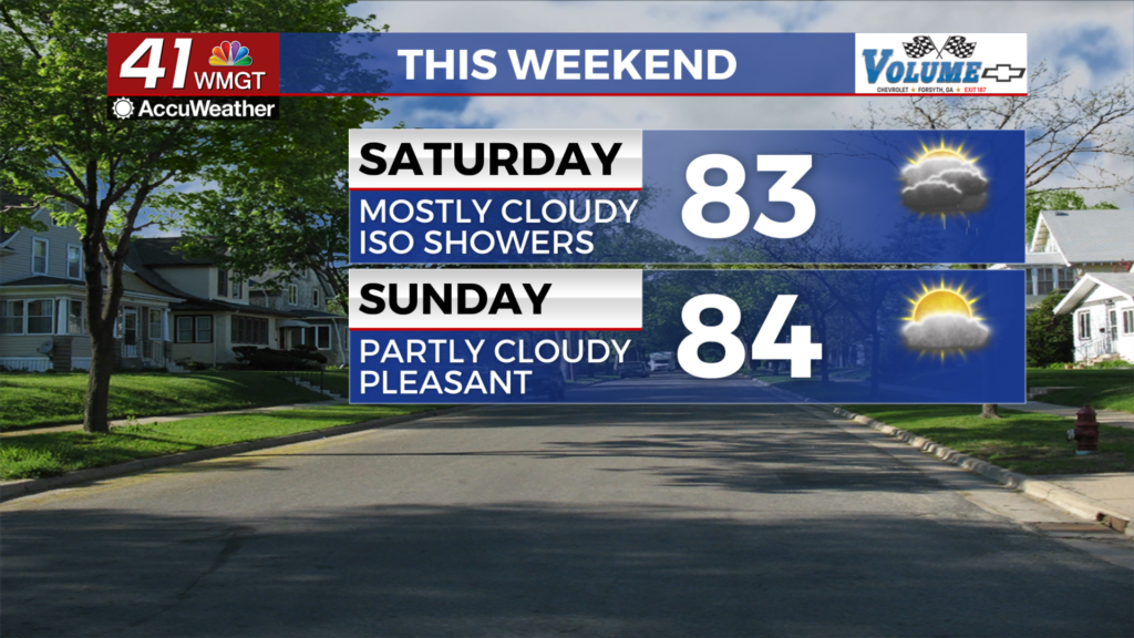
A mostly cloudy day is likely Saturday with highs only reaching the lower 80s for much of the region. Some sunshine will be possible in the late afternoon and evening. A few isolated showers will also be possible throughout the day. Wind will be light out of the north.


Overnight will see some more clearing with the clouds as lows drop into the low to mid 60s. Wind will be light from the north-northeast. Rain is not expected.
Sunday and Beyond


A partly cloudy day is expected Sunday with a slim chance for a shower in the eastern reaches of Middle Georgia. Highs will largely reach the mid 90s accompanied by light wind from the northeast.

Next week is a tough forecast as it is dependent on what happens with Invest94L. It likely will earn the name Imelda at some point through the weekend and guidance at this time suggest landfall in South Carolina is possible. This would lead to increased rain odds, cloud cover, and wind for much of Georgia throughout next week. Should 94L go out to sea, however, the forecast will likely lean towards mostly sunny and pleasant.
The Tropics


As mentioned above eyes for the Southeastern US will remain on Invest94L through the weekend. Humberto is further east in the Atlantic and has rapidly intensified into a Major Hurricane. It will stay out to sea.

Follow Chief Meteorologist Aaron Lowery on Facebook (Aaron Lowery 41NBC) and X (@ALowWX) for weather updates throughout the day. Also, you can watch his forecasts Monday through Friday on 41NBC News at 4, 5, 5:30, 6, and 11 p.m.