

Temperatures and storm chances go up for Middle Georgia later in the week
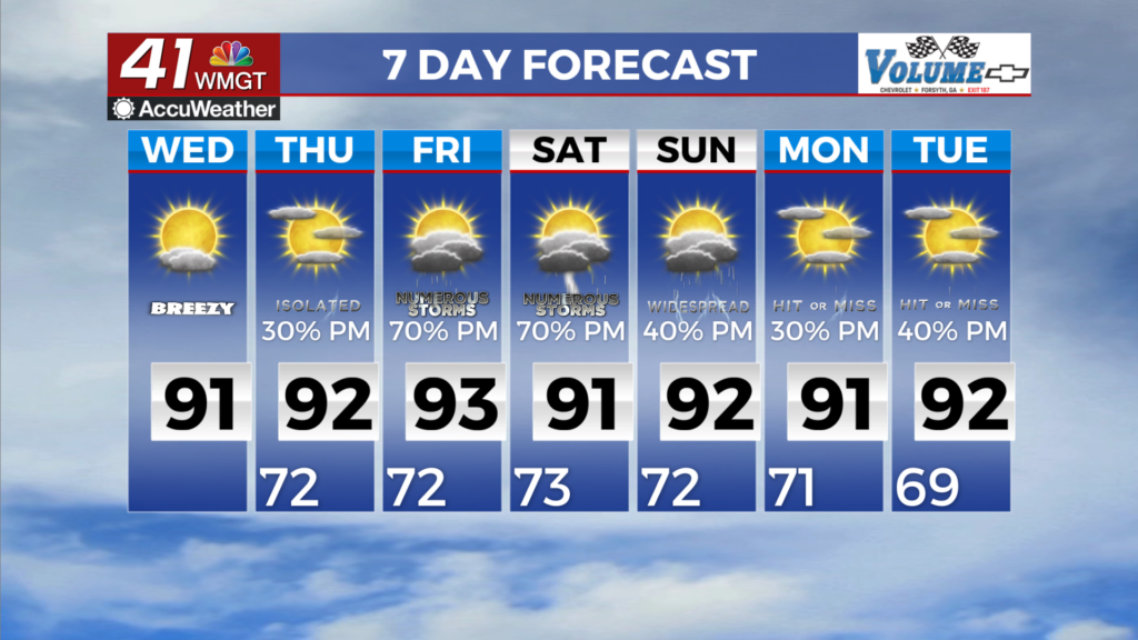
MACON, Georgia (41NBC/WMGT) – A mid-level ridge slides over the Southeast today, which will keep most of the area warm and rain-free. There will be a strong moisture gradient starting to 


develop across the area today, with lingering dry air in North Georgia, and moisture pushing into Middle Georgia. By this afternoon, dewpoints will be in the low to mid 60s in North Georgia. Meanwhile, in Middle Georgia, dewpoints will be in the low to mid 70s, with high moisture levels. This amount of moisture could support isolated afternoon showers and weak storms, mainly for areas south and east of Macon. Temperatures will warm to the low 90s across the area, with higher heat index values in the upper 90s to near 100 in Middle Georgia where the higher dewpoints are. On Thursday, the mid-level ridge slides off the east, with winds over the area turning out of the south. These southerly winds will push the moisture further north, resulting in isolated to 


scattered afternoon showers and storms as far north as the I-20 corridor. High temperatures will again be in the low to mid 90s, with heat index values in the upper 90s to low 100s across most of the area. The synoptic pattern over the area will start to shift on Friday, as the flow turns out of the southwest with a ridge off to the east, and troughing from the Ohio Valley down to the lower Mississippi Valley. Moisture will begin to draw up across the area from the Gulf on Friday, supporting scattered to numerous showers and storms. High temperatures in the low to mid 90s and dewpoints in the low to mid 70s will drive peak heat index values into the 100 to 105 range across the area. By Saturday, higher moisture content spreads across the entire area, with enhanced forcing from a trough over the Tennessee Valley supporting more widespread showers and storms. While a few storms Friday and Saturday could be strong with gusty winds, we could also see a threat for localized flash flooding for any areas that are hit with repeated rounds of storms. Cloud cover may limit how warm temperatures get on Saturday, but generally expecting highs to reach the low 90s, with heat index values in the upper 90s to low 100s.