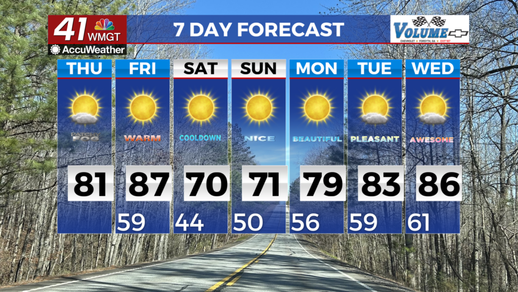
Sunshine continues into Monday; clouds to return overnight.
MACON, Georgia (41NBC/WMGT) – The pleasant weather from the weekend is carrying into the start of the new week.
Today


The cold mornings returned to the Peach State overnight Saturday, and that trend continued today. Almost half of Middle Georgia woke up to temperatures below 40 degrees and almost all locations saw wind chills below 40. The skies were clear as well, allowing for easy views of the sunrise. The weather is perfect for anyone planning to attend the Cherry Blossom Festival: the high for Macon this afternoon is 74 degrees. The rest of the region will climb into the mid to upper 70s as well. Winds from the southeast at 5-10 mph will continue to make things feel warm as well as return humidity to the atmosphere. Cloud cover will be minimal, though some thin clouds will begin to populate the area as the evening draws on.


Overnight that cloud cover will continue to thicken as the winds continue to blow from the southeast at the same rate. Most of the clouds will fill in after midnight. Low temperatures around the region will jump upwards of 10 degrees from Monday morning, only dropping into the upper 40s and lower 50s.
Tomorrow


The sunrise around Middle Georgia will be mostly obscured from view thanks to all of the additional clouds. Despite the cloud cover, however, there will be plenty of heat in the afternoon. Highs around the region will reach the upper 70s and lower 80s. A few pockets of sunshine are likely during the afternoon, however the skies will be dominated by clouds. The wind will come in from the south-southeast at 10-15 mph, continuing to add heat and humidity to the Georgia atmosphere. In fact, tomorrow’s heat will largely be driven by those southeasterly winds as a warm front pushes through.


Heading into tomorrow night winds will only pick up more speed, still coming in from the south-southeast. Gusts at this point could reach upwards of 25-30 mph. This will keep lows in the low to mid 60s heading into Wednesday morning. Rain could also possibly move in ahead of the sunrise Wednesday, but there is still a lot of uncertainty in terms of timing with the next system.
Wednesday and Beyond


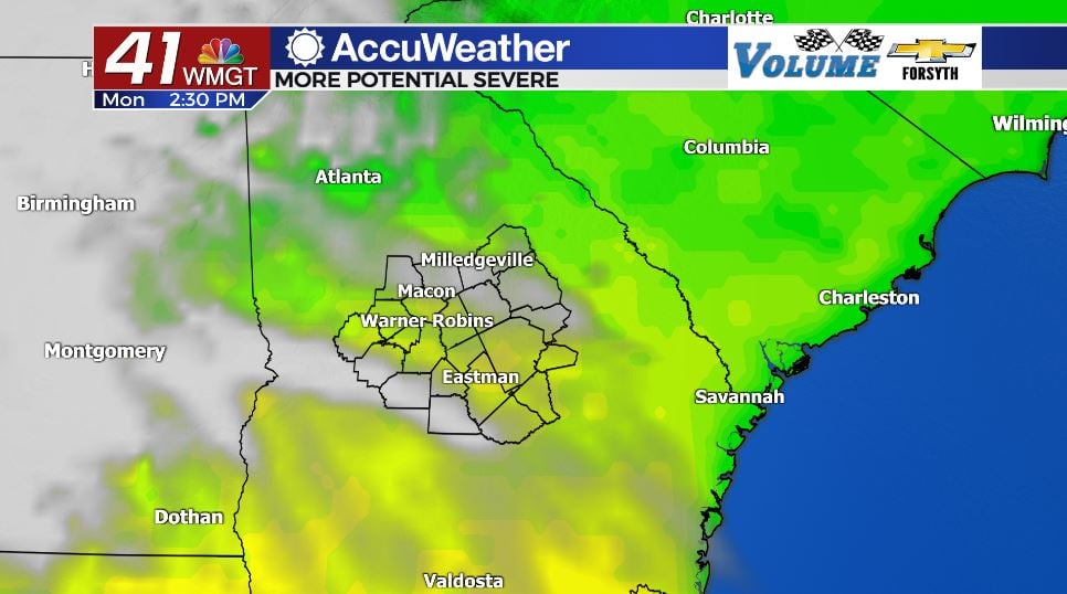
Wednesday could begin on a very rocky note as thunderstorms move in to kick off the day. As mentioned above, there is a lot of uncertainty with the timing of these storms. Some models have forecast them to arrive before the sunrise Wednesday morning while others have held the line back until lunchtime. That’s a very large disparity to be seeing only two days out, especially when severe weather is likely on the table. As of now the risk for Wednesday around Middle Georgia is a Level 2 “Slight” for all counties in the region. Primary threat looks to be powerful wind gusts due to intense downbursts.

Thursday will see the clouds from Wednesday’s system clear out as the actual cold front passes through. This could bring a couple of small showers, but the worst of this week’s weather is expected Wednesday morning.
The sunshine will be back on Friday, however scattered cloud cover is likely in the afternoon. Temperatures over the back half of the week are expected to steadily decline, dropping into the low 60s over the weekend in some spots. This will luckily be accompanied by sunny skies.

Follow Meteorologist Aaron Lowery on Facebook (Aaron Lowery 41NBC) and Twitter (@ALowWX) for weather updates throughout the day. Also, you can watch his forecasts Monday through Friday on 41NBC News at Daybreak (6-7 a.m.) and 41Today (11 a.m).