Sunny weather kicks off the new week
MACON, Georgia (41NBC/WMGT) – Clear conditions will continue to hang around Middle Georgia as a new week begins.
Today


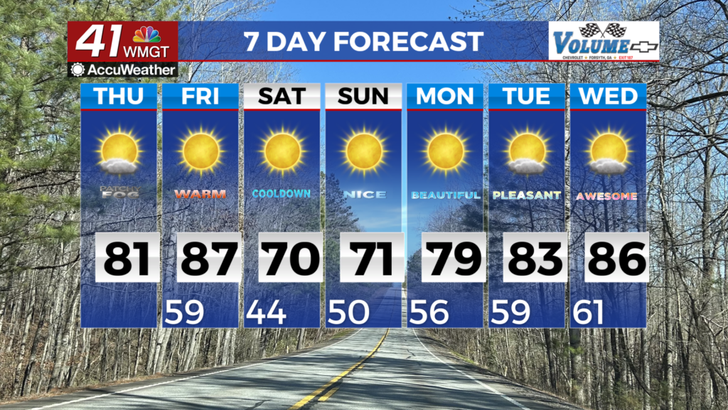
Cold weather made a big return over the weekend after a powerful cold front brought snow to northern Georgia and powerful winds and frigid temperatures to the majority of the state. This morning was no different as most of Middle Georgia kicked the day off with sub-freezing temperatures. The good news is the cold will not stick around long as highs this afternoon will reach the upper 60s and lower 70s. There will be a couple of clouds that build in this afternoon, but overall skies will be sunny.


There is a bit of concern for fire weather this afternoon as humidity values around Middle Georgia drop below 25%. This combined with breezes from the southeast that could gust up to 15 mph is enough for minor concern in relation to fires starting. Humidity values will begin to rise overnight as more cloud cover builds in, however no rain is expected. The overnight wind will continue to blow from the southeast at 5-10 mph. Low temperatures will drop into the mid to upper 40s around the region.
Tomorrow


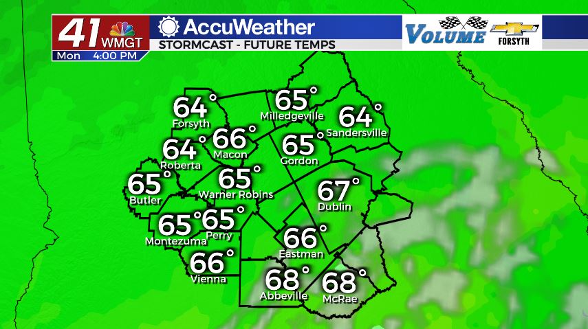
A new rain train is set to begin tomorrow afternoon. Mostly cloudy conditions will hang around most of the Peach State from sun up until sundown as temperatures again reach the upper 60s and lower 70s. This time, however the warmest cities will be in the eastern counties of the region instead of just the southeastern counties. This is due to rain moving in during the afternoon from the southwest. It will likely begin in the afternoon as showers, but as the evening hours draw on the northwestern counties of Middle Georgia will likely see heavy rain move in.


The heavy rain will become a bit more widespread around the region overnight, however severe weather is not expected. In fact, overall thunderstorm activity will be very limited if there is even any at all. The best chance for thunderstorms would be early on Wednesday morning, just ahead of the sunrise. This will correspond with low temperatures in the low to mid 50s around the region.
Wednesday and Beyond


The rain should stop pretty early on Wednesday, however as of now it seems likely that a good chunk of the cloud cover will remain overhead most of the day. A couple of isolated showers and storms will likely be possible Wednesday evening.

Thursday will also see limited opportunities for rain, however the skies will again remain at least partly cloudy. With highs in the 70s and limited sunshine, overall things should be pretty pleasant for St. Patrick’s Day.
Friday will bring our next best chance for rain as another system looks to push through leading into the weekend. It is too far out to determine if there will be a severe threat at this time.

Follow Meteorologist Aaron Lowery on Facebook (Aaron Lowery 41NBC) and Twitter (@ALowWX) for weather updates throughout the day. Also, you can watch his forecasts Monday through Friday on 41NBC News at Daybreak (6-7 a.m.) and 41Today (11 a.m).