Sun sticks around Wednesday; rain returns early Thursday
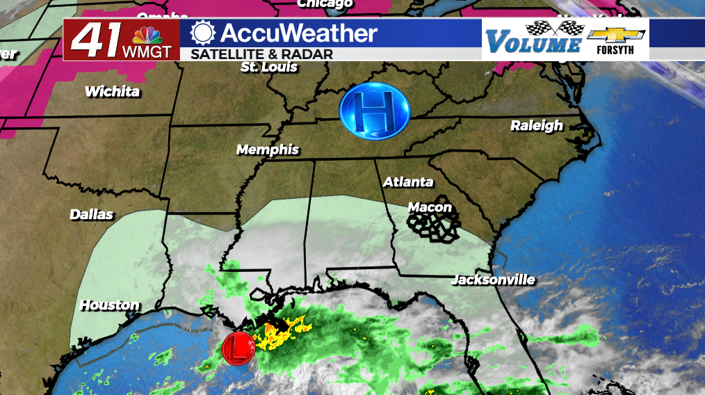
MACON, Georgia (41NBC/WMGT) – High pressure will keep the sun over Middle Georgia for one more day before a gulf system brings storms the rest of the week.
Today


High pressure over the Appalachians will keep Middle Georgia sunny and dry for one more day. Cirrus clouds will begin to enter the region from the south in the afternoon. Temperatures will largely peak in the upper 70s with a few spots eclipsing the 80 degree mark. Winds will continue to flow in from the east at about 5-10 mph. While gusts could reach as high as 20 mph they will largely remain below 15. UV Indexes around the region will hover around the 8 mark, meaning it will take a little under 30 minutes before burning begins for those not wearing sunscreen.


Tonight cloud cover will thicken as the winds shift more towards the southeast. Some rain will likely enter the southwestern counties during the early morning hours, heading northward as the sun rises. Temperatures out the door in the morning will be in the mid to upper 50s as a result of the increased cloud cover and moisture.
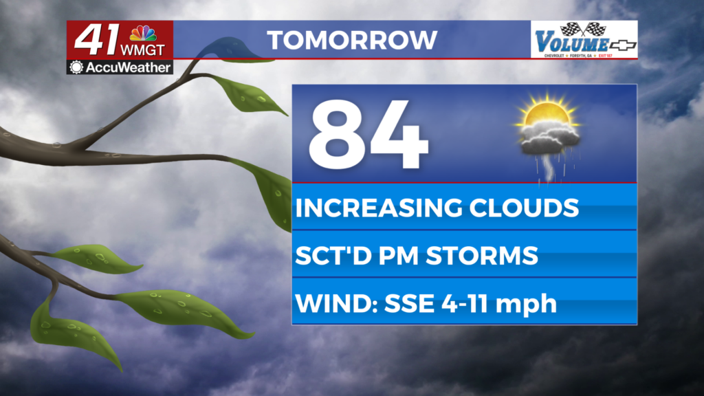
Tomorrow


Thursday has the potential to be a pretty active day with storms as the “rain bands” associated with the tropical low over Louisiana move from southeast to northwest through the region. For the most part these storms will just bring heavy rain and a few wind gusts, however a couple of brief spin-up tornados cannot be ruled out. The SPC has issued a Level 1 “Marginal” Risk that includes basically all of Middle Georgia to account for this. An upgrade to a Level 2 is likely once the SPC is able to narrow down where that tornado potential is highest.


Storm activity will last through much of the day with showers expected early and thunderstorms moving in around lunchtime. Temperatures will hang in the lower 70s for most of Middle Georgia with a couple of spots potentially staying below 70. Southeasterly winds will come in at about 10-20 mph with gusts upwards of 30 mph. Cloud cover will likely be a blanket for most of the region throughout the day tomorrow.


Overnight the rain is expected to back off along with the winds, however cloud cover will not budge. Low temperatures will be in the lower 60s across the region.
Friday and Beyond


Some lingering thunderstorms will be possible again Friday afternoon as the central low pressure from the gulf system moves through the Peach State. This time around, however, the tornado threat should not be present as the “rain bands” move further north into the Carolinas and Virginia. Rain should slow in the evening with cloud cover clearing overnight.
Saturday will be warm and sunny for the start with highs returning to the lower 80s, however cloud cover will return during the back half of the day with a chance for a few overnight showers.
Sunday will be a mostly cloudy day as a weak cold front moves through the region, bringing another round of thunderstorms. It is too far out at this time to know if there will be a severe threat with this front. Once it passes in the evening temperatures will cool and the humidity will drop into the start of next week as sunshine returns.

Follow Meteorologist Aaron Lowery on Facebook (Aaron Lowery 41NBC) and Twitter (@ALowWX) for weather updates throughout the day. Also, you can watch his forecasts Monday through Friday on 41NBC News at Daybreak (5-7 a.m.) and 41Today (11 a.m).