

Strong winds will lead to a warmup Wednesday
MACON, Georgia (41NBC/WMGT) – Wind from the southwest will gust over 20 mph around Middle Georgia tomorrow as highs reach back into the 60s.
This Evening
The clouds were again pretty stingy to get the day going, however rolling into lunchtime the sun finally began to poke through. A few clouds will remain heading into the overnight hours and should be clear most of tonight. Lows will drop below freezing around the region with some spots dropping into the upper 20s. Wind will be light from the southwest-southwest at around 5 mph.
Tomorrow
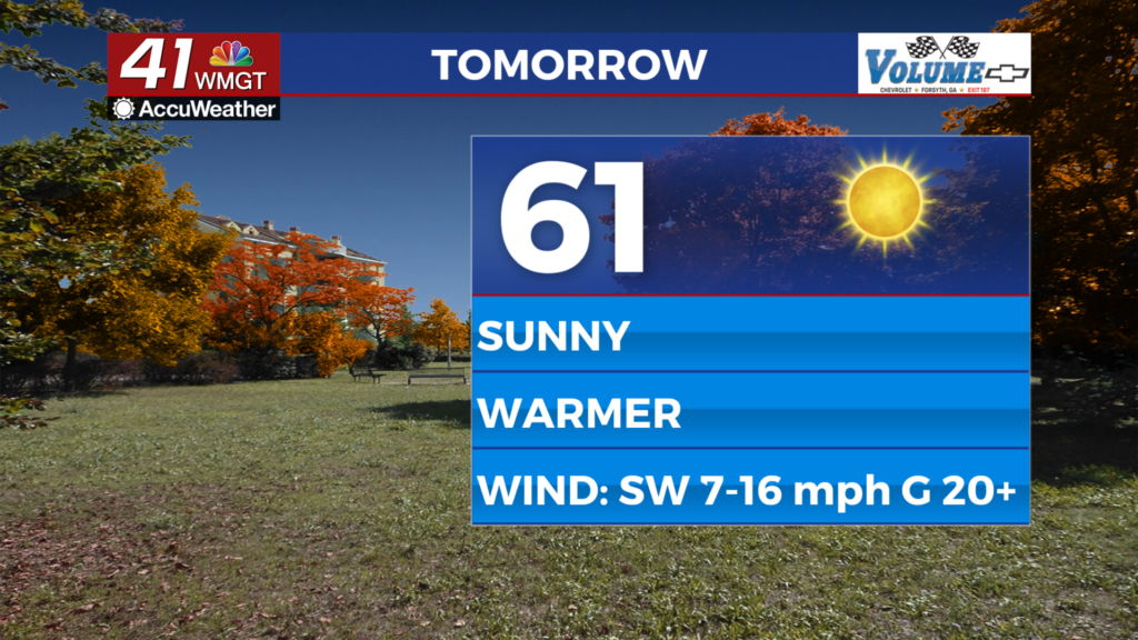
A fully sunny day is expected Wednesday and it will be more pleasant as well as temperatures climb into the lower 60s around the region. However these warmer conditions will be accompanied by strong wind from the southwest. Gusts will push over 20 mph with sustained speeds ranging from 7-17 mph.


Overnight will be mostly clear with lows likely to climb back above freezing. It will still be cold, however, as basically everywhere will still drop below 40 degrees. Wind will flow from the west-northwest at 8-15 mph. Gusts could still reach as high as 20 mph.
Thursday and Beyond
Thanks to a weak cold front moving through Wednesday night highs on Thursday will return to the low to mid 50s across Middle Georgia. The wind will be a bit breezy from the northwest. However, high pressure moving through the area Thursday night will lead to that wind shifting to back out of the southwest again on Friday, returning highs back above 60 degrees to end the work week. A few showers or perhaps a storm could be possible over the weekend.

Follow Chief Meteorologist Aaron Lowery on Facebook (Aaron Lowery 41NBC) and X (@ALowWX) for weather updates throughout the day. Also, you can watch his forecasts Monday through Friday on 41NBC News at 4, 5, 5:30, 6, and 11 p.m.