
Strong winds likely Wednesday afternoon
MACON, Georgia (41NBC/WMGT) – Northeast winds will be gusty throughout the day on Wednesday keeping temperatures below average.
This Evening
Conditions will remain clear through the evening and into tonight however scattered high level clouds may move in ahead of sunrise. A Red Flag Warning for fire danger remains in effect for Crisp, Dodge, Telfair, Wheeler, and Wilcox Counties until 8 PM EDT. Middle Georgians in these locations should avoid activities involving fire until after sundown. Temperatures should drop into the mid to upper 40s around the region. Wind will be breezy at times from the northeast as gusts could still reach as high as 20 mph. Sustained speeds should be in the 5012 mph range.
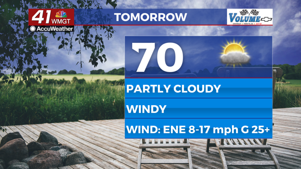
Tomorrow
Wednesday will be a pleasant day with plenty of wind across Middle Georgia. Winds will range from 10-17 mph with gusts from 20-30 mph, still out of the northeast. Temperatures will largely peak around 70 degrees. As for the sky there is still conflict with model guidance as for what to expect, however cloud cover should be limited to upper level cirrus.


Overnight will be mostly cloudy as more of those cirrus clouds pass over the region. Low temperatures by Thursday morning should be a bit below average with many spots likely to get into the low-mid 40s. The wind will continue from the northeast at 6-12 mph with gusts reaching as high as 20 mph.
Thursday and Beyond
Partly to mostly sunny skies are likely Thursday as temperatures climb into the low to mid 70s. The wind will still be a bit breezy, becoming calmer by Friday afternoon. A reversal in wind direction is expected on Saturday that will lead to afternoon temperatures climbing back into the 80s over the weekend.

Follow Chief Meteorologist Aaron Lowery on Facebook (Aaron Lowery 41NBC) and X (@ALowWX) for weather updates throughout the day. Also, you can watch his forecasts Monday through Friday on 41NBC News at 4, 5, 5:30, 6, and 11 p.m.