Strong to severe storms possible Thursday night
MACON, Georgia (41NBC/WMGT) – A cold front arriving tonight could bring some strong to severe storms to Middle Georgia.
Today


It was a humid morning to begin the day as cloud cover began to fill in quickly ahead of the sunrise. Temperatures this morning were the warmest so far this week, and some of us could have an even warmer morning tomorrow. Cloud cover will slowly spread southward throughout the day today with the northern counties likely to see blanket conditions most of the afternoon. A few isolated showers will be possible around the region later today as well. The wind will also be quite noticeable this afternoon as it comes in from the south at 15-20 mph. Gusts are likely to hang in the 25-40 mph range, especially during the later afternoon and evening hours ahead of the cold front. High temperatures during the afternoon will be the warmest we see this week as most locations climb into the lower 80s.


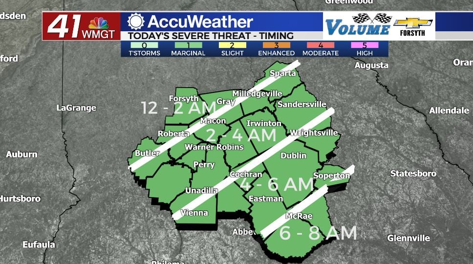
Tonight conditions will remain rather warm until the cold front arrives, providing plenty of energy for storm activity. The cold front is likely to arrive in Middle Georgia shortly after midnight with heavy rain and strong straight-line winds. If there is going to be a tornado threat tonight, it will likely be in independent cells that form ahead of the line. The good news is that conditions leading into tonight do not really support that development, keeping the tornado risk extremely low. Unfortunately, however, the risk cannot be 100% ruled out and a brief spin-up tornado will be possible within the main line of storms.


Rain totals from the line tonight will range from about .1″ to about .5″ with the northern counties in the region likely to receive more rain. The cold front will weaken quickly as it moves through, becoming showers in the southeastern counties ahead of the sunrise Friday morning. The wind will also shift from the south-southwest at 15-25 mph to the northwest at 10-15 mph as the front passes. Low temperatures around the region will range from the lower 50s in the northwestern counties to the mid 60s in the southeastern counties. Cloud cover will begin to clear out once the main line of storms has passed, potentially allowing some spots in Middle Georgia to see a spectacular sunrise to begin their Friday.
Tomorrow


A few showers may linger in the southeastern counties early, but by about 10:00 am the rain should be all but over with. Temperatures will only reach the lower to mid 60s around the region with very little change from the overnight hours being observed in the southeastern counties. The northern counties will see a day with mainly sunshine while the clouds will take a bit longer to clear in the southern counties. Winds will blow in from the northwest at about 10-15 mph with gusts upwards of 25 mph, chilling the air as well as drying it out.


Overnight skies will remain clear and low temperatures will drop below the seasonal average as they once again fall below freezing for most of the region. The wind will slow to about 5-10 mph, still coming from the northwest.
The Weekend and Beyond


Sunny skies will hang around for both Saturday and Sunday as high temperatures reach the lower and mid 60s during the afternoon on Saturday and then the upper 60s and lower 70s on Sunday. Cloud cover will likely not make much of a return until Sunday night when the winds begin to shift back towards the southeast.
Showers are likely for the northern half of Middle Georgia come Monday as heavier rain looks to take hold over much of northern Georgia early next week. Temperatures will remain well above average for much of next week as the 70s return by Monday across the board.

Follow Meteorologist Aaron Lowery on Facebook (Aaron Lowery 41NBC) and Twitter (@ALowWX) for weather updates throughout the day. Also, you can watch his forecasts Monday through Friday on 41NBC News at Daybreak (6-7 a.m.) and 41Today (11 a.m).


Leave a Reply