Strong to severe storms possible this afternoon; slight chance tomorrow
MACON, Georgia (41NBC/WMGT) – A cold front will bring very heavy rain and a chance for severe storms to Middle Georgia this afternoon and evening.
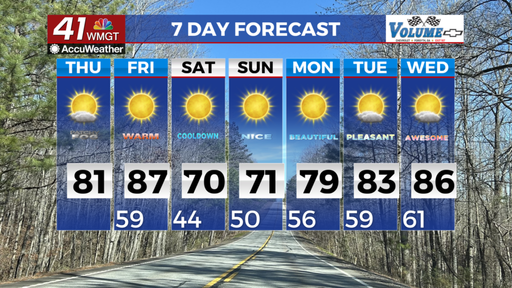
Today


Cloud cover wasted no time moving in after the sunrise this morning. Still, there will be plenty of warmth as we head into the afternoon hours. Highs will be in the 70s for most of the region, however the northwestern counties will likely top off in the upper 60s. Winds will come in from the south throughout the day with sustained speeds of 10-15 mph and gusts upwards of 25 mph. Rain is likely to move into Middle Georgia between 12:00 PM and 2:00 PM, slowly moving through the area the rest of the day.


As for the severe weather risk associated with the cold front, it is now a Level 2 “Slight” risk for most of the region. Only Baldwin, Hancock, Johnson, and Washington counties are excluded from the Level 2 risk. The primary threats with today’s storms will be powerful straight-line wind gusts as well as heavy rain with flash flooding potential. The flash flooding will mainly be a risk for low-lying areas. Hail and tornadoes are not nearly as likely given that most of the storms will be embedded in a squall line as the front trudges through. However, a spin-up tornado could still form in the line, especially if it should end up taking on more of a quasi-linear structure. As of now, the line is bowing out in Alabama, which suggests very powerful gust fronts and straight line winds as the line arrives.


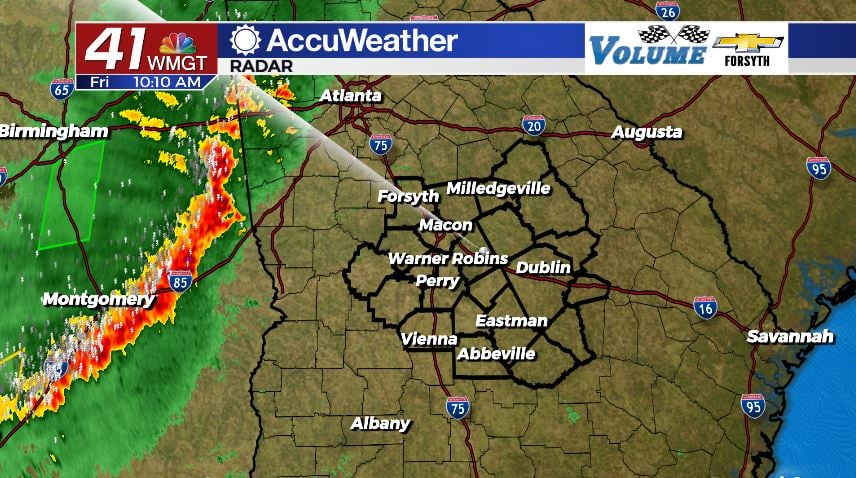
The rain should slow not too long after the sunset with scattered showers remaining possible into tonight. Some of them may have rumbles of thunder as temperatures will be staying rather warm: lows in the northern counties will be in the lower 60s and for the southern counties the upper 60s. This is setting the stage for few storms to fire up tomorrow afternoon in the southern counties where the SPC has already gone ahead and put out a Level 2 “Slight” Risk. It includes Telfair and Wheeler Counties.
Saturday

It is truly a mixed forecast for the region tomorrow. The northern counties will see overall pleasant conditions as the sunshine makes a return. Models have been suggesting highs in the low to mid 70s however recent runs have been trending more towards the upper 60s. This is likely due to a slight change in the wind forecast for Saturday afternoon from a westerly flow to a more west-northwesterly flow.


For the southern counties, severe weather is unfortunately going to be possible. Cloud cover will likely hang around south of I-16 most of the day with plenty of heat still lingering from Friday night. This could support some storm development in counties such as Laurens, Wilcox, Telfair, Wheeler, or Treutlen in the afternoon. The primary severe weather risks will remain off to the east tomorrow, however should they fire up over our region the primary threats will again be some quick heavy downbursts of rain and strong winds. A tornado, however, cannot be ruled out if the stormy activity does live up to the hype. By the time the rain stops, most of Middle Georgia will have received between .75″ and 2″ of rain between Friday and Saturday


Overnight conditions will clear and temperatures will finally begin to feel cold again as lows return to the low 40s. Winds will generally blow from the north at around 5 mph.
Sunday and Monday
Sunshine will hang around all day on Sunday following the clearing conditions of Saturday night. Northwesterly winds will keep things pleasant in the afternoon when highs reach the 70s once again. Overnight lows into Monday morning will drop into the low 40s around the region.
Monday will begin sunny but clouds are likely to build during the afternoon hours as the winds shift back to the south. Highs will again be in the 70s. Expect mostly cloudy conditions overnight and into Tuesday. Lows will climb back into the low to mid 50s as a result.

Follow Meteorologist Aaron Lowery on Facebook (Aaron Lowery 41NBC) and Twitter (@ALowWX) for weather updates throughout the day. Also, you can watch his forecasts Monday through Friday on 41NBC News at Daybreak (6-7 a.m.) and 41Today (11 a.m).