Strong thunderstorms possible for parts of Middle Georgia Saturday
MACON, Georgia (41NBC/WMGT) – A cold front arriving Saturday evening will bring thunderstorms to Middle Georgia, some of which could be strong.
The Rest of the Evening


Mostly cloudy skies will stick around as the odds for isolated showers or thunderstorms gradually increase. Temperatures will be slightly cooler than last night with low temperatures in the upper 50s and lower 60s. Winds will come from the south-southeast at about 5-10 mph. Gusts could push 20 mph, especially with any overnight storms. No severe weather is expected
Tomorrow


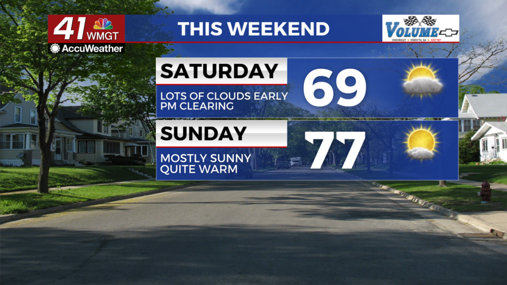
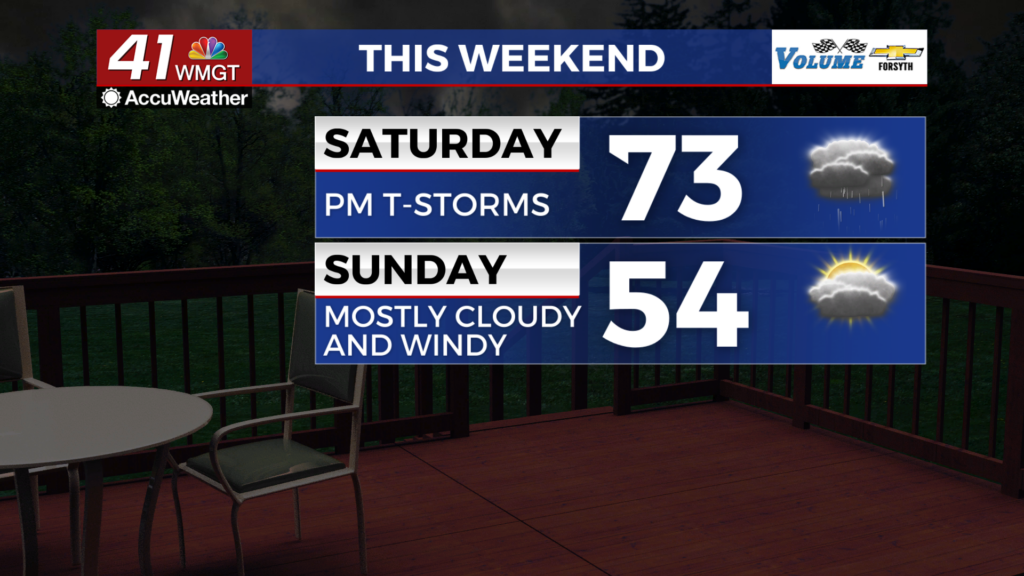
It will be a cloudy start with a few showers and perhaps a thunderstorm ongoing as the sun rises. Early shower activity will subside during the late morning hours before thunderstorm odds increase in the late afternoon as the cold front nears. Temperatures will climb into the mid 70s for most of the region with strong ambient wind coming in from the south-southwest at about 10-20 mph. Gusts could push over 30 mph.


A Level 1 “Marginal” threat for severe weather exists for the northwestern 3rd of the region. The main threat will be strong wind gusts, however storms will be weakening as they cross into Georgia from Alabama.


A few storms and showers will linger into the early parts of tomorrow night with a few stray showers remaining possible into early Sunday. Temperatures will be a bit cooler as they fall into the upper 40s and lower 50s with the wind shifting towards the west-northwest at about 10-20 mph. Gusts could push over 30 mph. A few breaks in the clouds are expected, but they will fill back in during the morning hours Sunday.
Sunday and Beyond


Sunday will be a mostly cloudy day as excess low-level moisture wraps around the back side of the low pressure. This could lead to a few small showers or perhaps some mist Sunday. Temperatures will be rather cool as they only reach the low to mid 50s during the afternoon. Wind chills could be in the upper 40s, however, as the wind comes from the northwest at 10-20 mph with gusts still pushing over 30 mph.
Cloud cover will work to clear out overnight as temperatures fall into the upper 30s and lower 40s. Winds will remain strong from the northwest at 10-17 mph, gusting to over 25 mph.

Sunny conditions are expected most of next week, however a few showers look to be possible late Wednesday and into early Thursday. Temperatures will be cooler than this past week as they return closer to average.

Follow Meteorologist Aaron Lowery on Facebook (Aaron Lowery 41NBC) and Twitter (@ALowWX) for weather updates throughout the day. Also, you can watch his forecasts Monday through Friday on 41NBC News at 4, 5, 5:30, 6, and 11 p.m.