Storms return tomorrow; stay through the weekend
MACON, Georgia (41NBC/WMGT) – A new storm system will bring plenty of chances for rain starting Friday and lasting through the weekend.
This Evening and Overnight


Scattered clouds from the afternoon will clear initially heading into tonight, however thicker clouds will begin to arrive from the west after midnight. This is thanks to a warm front passing through, increasing temperatures as well as humidity. Winds will be light and variable heading into Friday morning as temperatures reach their valleys in the mid to upper 60s. Some light rain could be moving into the western counties of Middle Georgia as the sun begins to rise.
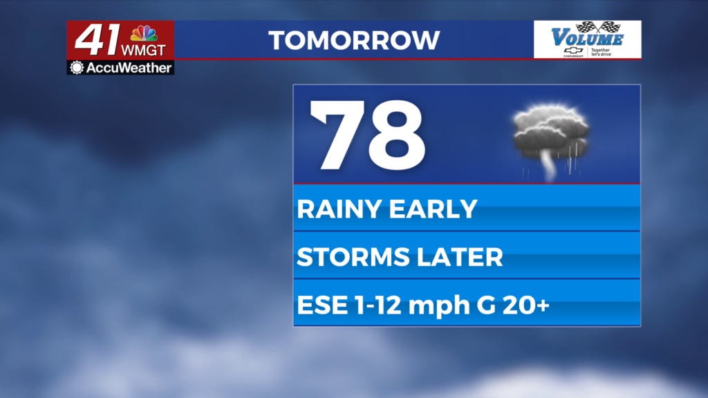
Tomorrow


Friday will be a gloomy day as overcast skies stay around all day. Light stratiform rain will likely be ongoing for the western counties during the sunrise hours with that rain pushing eastward through the morning. This will stunt temperatures heading into the afternoon with highs expected to be in the upper 70s and lower 80s. Ambient winds will largely come from the east-southeast at about 5-15 mph, gusting over 20 mph.


Thunderstorm activity will likely begin during the lunchtime hours and continue into the early evening before slowing some, however more storms could be possible overnight as well. A Level 1 “Marginal” risk is in place for a good chunk of Middle Georgia for tomorrow afternoon and evening with strong winds gusts or a bit of hail being the driving risks. A Level 2 “Slight” risk lurks just to the southwest of the region, however.


Overnight a few showers or a couple storms will remain possible, especially pushing towards Saturday morning. Overnight lows will be in the upper 60s and lower 70s heading into Saturday. Ambient winds will predominantly be out of the south at about 7-15 mph, still gusting over 20 mph.
This Weekend


Saturday will bring another widespread bout of thunderstorms to Middle Georgia with much of them expected in the afternoon and evening. Highs will again be in the upper 70s and lower 80s, however winds will now have their typical southwesterly flow ahead of a cold front. Winds could range from 5-17 mph, gusting as high as 30 mph. A Level 1 “Marginal” risk for severe weather currently includes the entirety of Middle Georgia, however the chances for an upgrade to a Level 2 “Slight” risk are definitely greater than zero.

Sunday will again be mostly cloudy as the low pressure system itself passes through the region, bringing even more rain in the form of scattered showers/storms. While these likely will not have a severe risk, a flooding risk could begin to emerge in some parts of the region after all the rain from Friday and Saturday. Cloud cover will stick around through Monday of next week before the sunlight finally returns again Tuesday.

Follow Meteorologist Aaron Lowery on Facebook (Aaron Lowery 41NBC) and Twitter (@ALowWX) for weather updates throughout the day. Also, you can watch his forecasts Monday through Friday on 41NBC News at 4, 5, 5:30, 6, and 11 p.m.