
Storms likely Wednesday afternoon and evening
MACON, Georgia (41NBC/WMGT) – An incoming cold front will bring isolated to scattered storms around Middle Georgia over the back half of Wednesday.
This Evening
It’s been another mostly cloudy day for much of Middle Georgia however despite that highs still reached the mid 80s with real feels into the 90s in the warmest spots. The wind is light and will continue to be as it flows from the southeast the rest of the night. A few showers and perhaps a thunderstorm remain possible through the rest of the evening, however overnight rain is not expected. Lows will be in the mid to upper 60s around the region. Fog will be possible ahead of sunrise tomorrow morning.
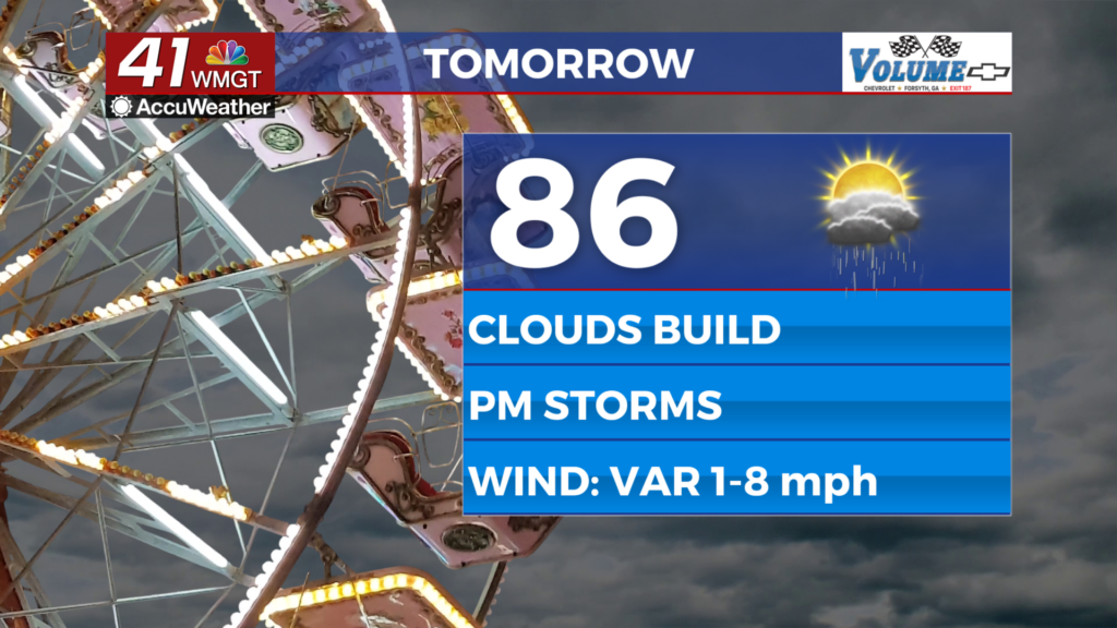
Tomorrow
A mix of sun and clouds is likely early with more clouds filling in during the afternoon. Highs will reach the mid to upper 80s again with real feels pushing the 90s for the 3rd time this week. Isolated to scattered storm activity is likely to begin around lunchtime and will peak during the evening hours. Severe weather is not expected.


Overnight will be mostly cloudy with a few showers and perhaps a storm lingering. As the night progresses rain odds will drop. Expect lows in the mid 60s for much of the region accompanied by northeasterly winds at 5-10 mph.
Thursday and Beyond
A string of much cooler days will begin Thursday as the effects of the cold front from Wednesday take hold. Highs should largely be in the mid 70s Thursday under partly cloudy skies and the lower 70s Friday under partly sunny skies. There will be plenty of wind from the northeast both days as gusts push over 20 mph. The weekend will also be breezy with plenty of sun as highs stay below average.
The Tropics
Tropical Storm Jerry has been named in the Atlantic Basin and at this time is expected to turn north and stay out to sea. In the Gulf near the Yucatán Peninsula there is an area of interest with 10% odds to develop in the next 7 days. Odds are this will not be of concern to the United States.

Follow Chief Meteorologist Aaron Lowery on Facebook (Aaron Lowery 41NBC) and X (@ALowWX) for weather updates throughout the day. Also, you can watch his forecasts Monday through Friday on 41NBC News at 4, 5, 5:30, 6, and 11 p.m.