


Storm chances drop again Thursday
MACON, Georgia (41NBC/WMGT) – The odds for isolated storms will drop Thursday afternoon while conditions remain warm around Middle Georgia.
This Evening
A few storms are ongoing this afternoon and a few more remain possible as the evening continues. Rain activity should taper off by midnight tonight. No severe weather is expected but a few storms may have small hail or relatively strong wind gusts. Frequent cloud-to-ground lightning is also likely with any storms that mature.


Once the storms clear out a few clouds will linger with temperatures likely to drop to around 60 degrees. The moon will be full tonight and should be easily visible around Middle Georgia. It is called the Full “Pink” moon for the abundance of a small pink flower known as Moss Phlox that grows this time of year. Wind will be light from the south-southeast.
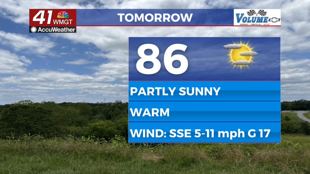
Tomorrow
A partly sunny and warm day is likely around Middle Georgia as temperatures climb into the mid to upper 80s. The wind will flow from the southeast at 5-12 mph with gusts ranging from 15-20 mph, so expect it to be breezy at times. A couple showers or a storm are possible, however odds should be a good bit lower than Wednesday afternoon.


Overnight will see partly cloudy skies and temperatures that valley in the lower 60s. The wind will flow from the southeast at around 5-12 mph with gusts over 15 mph.
Friday and Beyond
More clouds are likely to end the week but it will still be plenty warm with temperatures reaching the low to mid 80s. A bit less than half the region should see some rain activity, however a new trend with model guidance is suggesting those odds may drop. The next good chance for storms will be during the afternoon and evening of Easter Sunday.

Follow Chief Meteorologist Aaron Lowery on Facebook (Aaron Lowery 41NBC) and X (@ALowWX) for weather updates throughout the day. Also, you can watch his forecasts Monday through Friday on 41NBC News at 4, 5, 5:30, 6, and 11 p.m.