

Storm chances climb over the weekend
MACON, Georgia (41NBC/WMGT) – Conditions will stay hot and humid into the weekend until a cold front bring storms Sunday night and Monday.
This Evening
A partly cloudy and hot afternoon will become a partly cloudy and muggy night. Wind will continue from the south-southeast at 5-10 mph, calm enough for some fog to set in thanks to dewpoints that are in the mid to upper 60s. Low temperatures will also drop into the mid 60s. A stray shower cannot be ruled out, however rain is not expected overall tonight.
Tomorrow
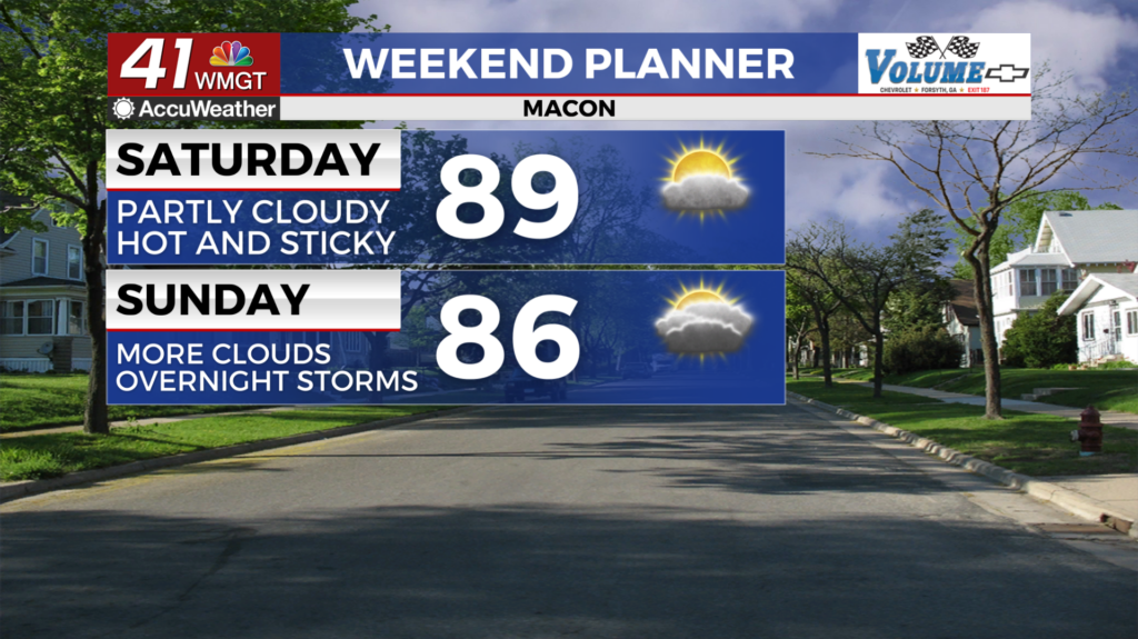
It will be another hot and muggy day with highs pushing the 90 degree mark with real feels eclipsing 90 degrees. A stray shower or two will be possible, and the wind will be quite balmy from the south-southwest. Expect sustained speeds to range from 7-15 mph, gusting over 20 mph.


Overnight could end up being mostly clear before fog sets in ahead of Sunday morning. Expect lows in the mid to upper 60s along with dewpoints. Wind will be from the south at 5-10 mph. Rain is unlikely overnight.
Sunday and Beyond
Cloud cover will fill in throughout the afternoon Sunday as highs reach the mid to upper 80s, or a few degrees cooler than Saturday. Expect it to be quite balmy with south-southwest wind blowing in at 10-20 mph as gusts range 25-30 mph. Rain chances will begin to climb in the evening, however overall storm odds will likely stay low until well after sunset.


Overnight is when storm odds will finally climb for Middle Georgia. A Level 2 “Slight” risk for severe weather currently includes the northwestern 3rd of the region. Strong winds, small hail, and a tornado or two will all be possible. Overnight lows will only be in the low to mid 60s with powerful winds from the south-southwest. Ambient gusts could range over 40 mph as storms roll in.

Monday will see more rain with a reduced severe threat. A Level 2 could still be possible for the southern counties of the region, however. Rain totals could be the highest seen in some time as the front is expected to move through slowly. This will bring much needed rain to Middle Georgia, however a flash flooding threat could be possible, especially in low lying areas.

Follow Chief Meteorologist Aaron Lowery on Facebook (Aaron Lowery 41NBC) and Twitter (@ALowWX) for weather updates throughout the day. Also, you can watch his forecasts Monday through Friday on 41NBC News at 4, 5, 5:30, 6, and 11 p.m.