Staying warm and mostly cloudy Tuesday
MACON, Georgia (41NBC/WMGT) – Temperatures will remain well above average as stubborn cloud cover hangs around Tuesday.
This Evening


Cloud cover was expected to break up this afternoon around Middle Georgia, however that has not been the case for most of the region. A bit more breakup may happen through the evening however, leading to a partly cloudy night overall. It will be above average in terms of temperatures with lows expected in the mid to upper 40s. Wind will be light from the south-southwest, and fog will be possible as well.
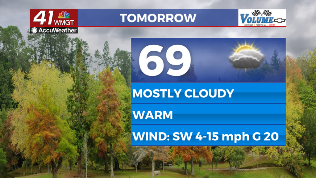
Tomorrow


Another mostly cloudy day is likely for much of Middle Georgia with a few spots leaning more towards partly cloudy. Highs will reach the upper 60s and lower 70s with breezy winds from the southwest gusting as high as 20 mph. During the evening hours a shower or two could be possible.


Overnight a shower or two will also be possible as skies will be partly to mostly cloudy. The wind will remain out of the southwest at 5-10 mph with gusts pushing to around 15 mph.
Wednesday and Beyond


A bit more sunshine is likely Wednesday following a cloudy start. This will allow temperatures to climb into the mid to upper 70s in the afternoon as the wind remains out of the south. Ultimately rain odds will climb to end the week as another cold front will pass through over the coming weekend. More will become clear about storm potential as the week goes on. The Storm Prediction Center has already highlighted a Level 2 risk for the ARK-LA-MISS Friday.

Follow Chief Meteorologist Aaron Lowery on Facebook (Aaron Lowery 41NBC) and X (@ALowWX) for weather updates throughout the day. Also, you can watch his forecasts Monday through Friday on 41NBC News at 4, 5, 5:30, 6, and 11 p.m.