Spring-like temperatures to stick around this week
MACON, Georgia (41NBC/WMGT) – High temperatures around most of Middle Georgia will return to the 80s beginning today.
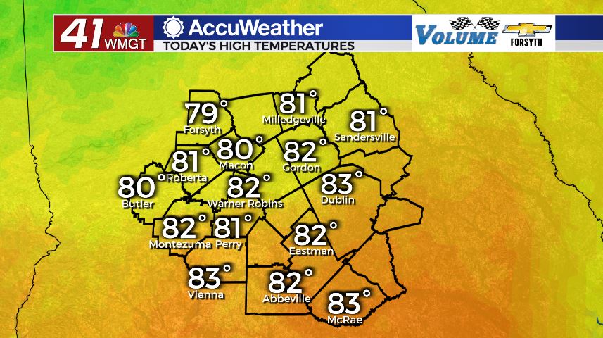
Today


There was plenty of cloud cover to begin the day in Middle Georgia along with plenty of warmth and humidity. If you’re someone who typically doesn’t get up until after 9 am, however, you would never know there was a blanket of clouds earlier. The skies around the region were almost completely clear by about 8:30 am, and mostly sunny skies will stick with us throughout the day. Due to the fact that high temperatures for most of the region are in the lower 80s, cloud fields are likely to develop in the afternoon due to surface heating, similar to what we often see during the spring and summer months. We will also see some strong balmy breezes from the south-southwest today as gusts reach the 25 mph mark.


Overnight more clouds will continue to fill in as low temperatures again stay warm; they will once again only drop into the upper 50s and lower 60s. Winds overnight will still be somewhat breezy, hanging in the 7-12 mph range from the southwest. Also similar to this morning the humidity will remain high and thus patchy fog will develop in some areas heading into tomorrow morning.
Tomorrow


More clouds are expected around Middle Georgia tomorrow than today, however overall this week the southern counties in the region will see very limited cloud cover. The northern parts of Georgia will be hit with plenty of clouds and rain come Wednesday, however high pressure and a stubborn ridging pattern will keep the warmth and sun over the southern half of the state. This means that here in Middle Georgia we are the middle ground: clouds are likely in the northern half of the region, however the rain chances will be limited to an isolated shower or two in Monroe or Jones Counties. Everybody else should avoid the rain as temperatures again climb into the lower 80s across most of the region. The wind will also still be breezy out of the west-southwest at 10-15 mph.


Overnight will be very similar to tonight with scattered clouds passing through and lows in the mid to upper 50s. Winds will calm to about 5 mph overnight as well as patchy fog develops yet again due to overall calm, warm, and humid conditions.
Thursday and Beyond


Thursday will bring more of the same as a mix of sun and clouds fill the sky with highs in the lower to mid 80s around Middle Georgia. Winds will continue to blow out of the south-southwest, though they shouldn’t be as breezy at 5-10 mph. Gusts could still reach close to 20 mph, however. Overnight lows will drop into the upper 50s and lower 60s for the 3rd night in a row.

Friday will finally bring a bit of a change as a cold front will begin to cool things off. There will be an abundance of cloud cover during the day as high temperatures reach the upper 70s for most of the region with a couple of lower 80s hanging around. Rain will be limited to a few showers again as the cold front arrives, suffering a similar fate to Wednesday’s due to stubborn high pressure.
The next good chance for rain will be Sunday, and beyond that temperatures will become more seasonal as highs return to the mid to upper 50s with lows in the lower and mid 30s.

Follow Meteorologist Aaron Lowery on Facebook (Aaron Lowery 41NBC) and Twitter (@ALowWX) for weather updates throughout the day. Also, you can watch his forecasts Monday through Friday on 41NBC News at Daybreak (6-7 a.m.) and 41Today (11 a.m).


Leave a Reply