


Snow likely Saturday along with plenty of wind
MACON, Georgia (41NBC/WMGT) – A low pressure system off the coast of GA/SC will lead to some snow for much of Middle Georgia on Saturday along with strong and chilly winds.
This Evening
It’s been a mostly cloudy but relatively warm (when compared to the rest of the week so far) afternoon to cap off the work week. Wind has been pretty light from the southwest however gusts have been reaching around 15 mph. Conditions should stay dry until later this evening when a few showers will be possible. A shift in wind direction is likely around midnight with gusts quickly reaching 20+ mph by sunrise tomorrow from the northwest. Most overnight precipitation will be very isolated and also rain, but a shift to snow is likely around sunrise Saturday morning. Overnight low temperatures will largely drop into the upper 20s.
Tomorrow
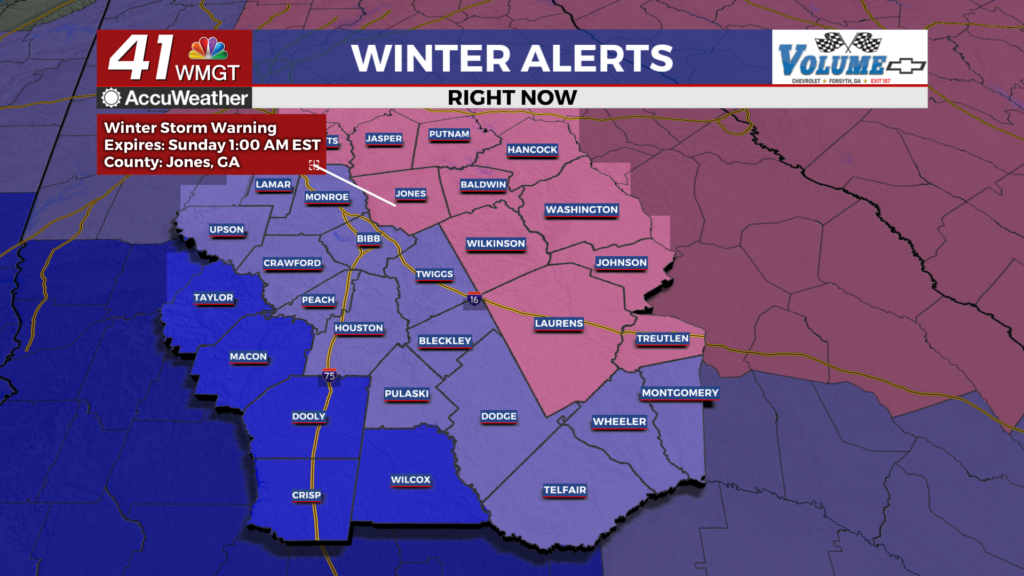
Heading into Saturday a good chunk of the region is under either a Winter Storm Warning (in effect until 1 AM Sunday morning) or Winter Weather Advisory (in effect until 7 PM Saturday evening) ahead of the winter system. Snow is likely to begin in the northeastern parts of Middle Georgia during the sunrise tomorrow. Temperatures may climb back into the lower 30s, but most spots will not get above freezing. The aforementioned snow will spread southwest through the late morning hours, reaching its peak activity during the mid afternoon. During this time the wind will be powerful from the northwest with sustained speeds ranging from 10-25 mph and gusts ranging from 25-40 mph. This will make visibility extremely low for much of the day.
Snow should taper off in the evening hours from southwest to northeast and cloud cover should follow closely behind. The wind, however, will remain very strong with gusts still pushing 30-40 mph through the overnight hours into Sunday morning. Temperatures overnight Saturday into Sunday are anticipated to drop into the mid to upper teens with wind chills in the single digits. As a result all of Middle Georgia is under an Extreme Cold Warning until 1 PM Sunday afternoon. This also means any accumulations from Saturday’s snow will remain intact into Sunday morning.
Sunday and Beyond
Sunny skies will be back on Sunday and afternoon temperatures should largely reach the upper 30s and lower 40s. Combined with wind still from of northwest at 10-20 mph (gusts upwards of 30 mph) this will help melt a decent chunk of whatever falls on Saturday.

The hardest hit areas however will likely not see everything melt and some re-freezing is likely overnight into Monday. This could lead to some treacherous travel Monday morning as patches of black ice will be likely, especially on backroads/roads that don’t see as much sunlight. Basically everything left on Monday should melt as temperatures Monday afternoon will push into the lower 50s across Middle GA.

Follow Chief Meteorologist Aaron Lowery on Facebook (Aaron Lowery 41NBC) and X (@ALowWX) for weather updates throughout the day. Also, you can watch his forecasts Monday through Friday on 41NBC News at 4, 5, 5:30, 6, and 11 p.m.

