Severe storms possible Thursday
MACON, Georgia (41NBC/WMGT) – A low pressure system originating in the Gulf of Mexico is driving a severe weather threat for Middle Georgia this afternoon.
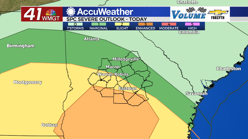
Today


The Storm Prediction Center upgraded the severe categorical risk over the southern counties in Middle Georgia to a Level 3 “Enhanced” risk at 9 am this morning. It includes Wheeler, Wilcox, and Dooly counties with portions of Dodge, Pulaski, Wheeler, and Macon Counties. The upgraded risk was applied due to an increased risk in tornado potential. While other modes of severe weather appear possible (small hail, strong wind gusts) the tornado threat is unfortunately the most likely. The threat looks highest during the later afternoon and evening hours.


On top of severe threats flash flooding will also be possible with some of these storms, particularly in areas that get hit with multiple of them. While the severe threat is largely the southern/southwestern counties, the flash flood threat in the region lies along and west of the I-75 corridor. Rain totals in some locations could push 2+ inches before today is done. There will also be plenty of wind throughout the day as it blows in from the east-southeast at 10-20 mph with gusts potentially over 30 mph. Temperatures will mainly top off in the lower 70s this afternoon.


Tonight the rain will slow as some of the cloud cover breaks up, however a few storms could linger. Temperatures will stay pretty warm as they only drop into the upper 50s and lower 60s. Humidity is not expected to drop as more rain is likely during the first half of our Friday. However, with winds calming a good bit ahead of tomorrow morning some fog will be possible in areas that saw lots of rain during the afternoon. There will also be plenty of shifting with the wind as it goes from the east-southeast in the evening all the way to the southwest by tomorrow morning.
Tomorrow


More storms are likely the first half of the day tomorrow with a few showers lingering into the late afternoon. At this time severe weather is not expected for our Friday. Winds will mainly blow from the southwest at about 5-15 mph and gusting upwards of 25 mph. Temperatures will be a bit warmer in the afternoon as they rise into the mid to upper 70s. Cloud cover should start to clear out heading into the evening hours.


It will be a mostly clear night heading into Saturday morning, however the humidity will still largely be intact from the gulf low system. Temperatures are only expected to drop into the mid to upper 50s by Saturday morning. Ambient wind will blow out of the west-southwest at around 5 mph. Fog will also be possible (likely in areas that see more rain Friday) to kick off Saturday around Middle Georgia.
This Weekend


Saturday will give us a break from the rain as the sunshine returns for most of the afternoon. Temperatures will peak in the low to mid 80s around the region. Ambient winds will blow out of the west at about 5-10 mph. Cirrus clouds will begin to fill in during the later afternoon hours with thicker clouds arriving during the evening and overnight hours. Some showers will be possible ahead of Sunday morning.
Sunday will see a cold front move through Middle Georgia and it will bring yet another round of storms. It is too early to tell at this point whether or not severe weather will be a concern, but temperatures will top off in the upper 70s/lower 80s (severe favorable) and plenty of moisture will likely remain following the passing of the Gulf Low on Friday. Limiting factors on this, however, are the fact that the low pressure system driving the threat will be well up in Canada and likely not in the best shape structure-wise as the front moves into Middle Georgia.
There is also some pretty big disagreement right now between mid-range model guidance: GFS (American) does not see much rain potential for Sunday at all while the Euro sees a good amount of rain arriving before sunrise and another round of plentiful rain in the afternoon thanks to cold front driven thunderstorms. Even if there is not too much rain, however, severe threats could still linger a bit. Sunnier conditions should return on Monday following the passing of that cold front Sunday evening.

Follow Meteorologist Aaron Lowery on Facebook (Aaron Lowery 41NBC) and Twitter (@ALowWX) for weather updates throughout the day. Also, you can watch his forecasts Monday through Friday on 41NBC News at Daybreak (5-7 a.m.) and 41Today (11 a.m).


