Severe storms likely Tuesday
MACON, Georgia (41NBC/WMGT) – An incoming cold front will bring powerful storms to Middle Georgia much of the day Tuesday.
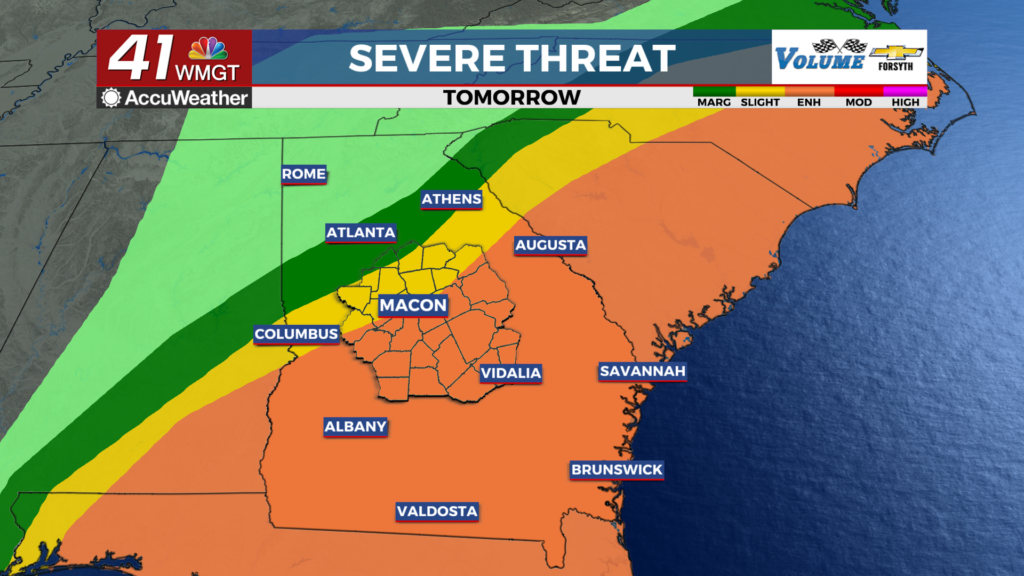
The Rest of the Evening


Clouds have filled in over the region and likely will not break up again tonight. Temperatures will largely bottom out in the mid to upper 40s this evening vs the usual next morning. Temperatures will then begin to slowly climb through tonight as a warm front comes through. This warm front will bring widespread moderate to heavy rain with a chance for a few rumbles of thunder. Winds will be rather strong tonight from the southeast, ranging from 10 to 25 mph. Gusts could be over 40 mph. Because of this, a Wind Advisory is in effect for all of Middle Georgia until 7 am Tuesday morning.
Tomorrow


Scattered showers and a couple of small storms will likely be ongoing at the start of tomorrow. The main line of storms should begin to enter the western counties of Middle Georgia between 8 and 10 am. During these cooler hours it is unlikely that independent cells form out front of the line, but the line itself will have powerful winds and could spawn a couple of brief embedded tornadoes. Most of Middle Georgia is under a Level 3 “Enhanced” risk for severe weather tomorrow, however the northwestern counties largely fall under the Level 2 “Slight” risk zone.


Middle Georgians should remain weather aware throughout the day. The line will likely re-intensify as it moves eastward with temperatures slowly warming. This could lead to a couple of independent cells in the Eastern part of Middle Georgia. The line will likely clear our eastern counties between 4 and 6 PM tomorrow afternoon.


The main risk will be severe winds (gusts over 70 mph and sustained around 60 mph), however a couple of tornadoes unfortunately do look possible thanks to high levels of lower level wind shear. This is mainly because of surface winds from the south-southeast (often we see them from the south-southwest instead), promoting better rotation odds at the lower levels. Hail, however, looks highly unlikely for anywhere in Middle Georgia. A flash flood threat will also be possible with rain totals between 2-4 inches likely for much of the region.

Tomorrow night will be partly cloudy as things clear out. Temperatures will drop into the mid to upper 30s for most of the region. It will, however, remain rather windy with sustained speeds likely to range from 10-20 mph. Gusts could still reach 30 mph.

Follow Meteorologist Aaron Lowery on Facebook (Aaron Lowery 41NBC) and Twitter (@ALowWX) for weather updates throughout the day. Also, you can watch his forecasts Monday through Friday on 41NBC News at 4, 5, 5:30, 6, and 11 PM.