Scorching heat returns to Middle Georgia
MACON, Georgia (41NBC/WMGT) – High temperatures will be in the mid and upper 90s today and tomorrow around Middle Georgia.
This Evening


Cloud cover will remain rather sparse as we go through the evening hours. We could see a couple of spotty storms around the region, but almost all of Middle Georgia will stay dry. Winds will remain rather calm as they come in from the south-southwest at 4-6 mph.


Overnight lows will drop into the upper 60s and lower 70s. A few clouds may hang around overnight, but for the most part it will be a clear night with a sliver of a waxing crescent moon.
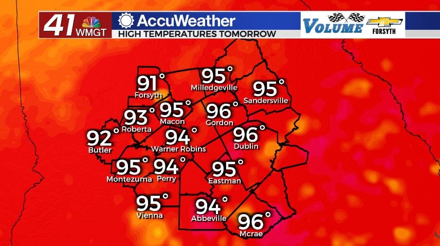
Tomorrow


It will be a scorcher of a day as our highs soar into the mid to upper 90s around the region. There will be plenty of sun with some scattered cloud fields forming in the afternoon. A couple of spotty showers will be possible in the late afternoon and evening hours. Winds will luckily be a bit stronger from the west-northwest at 5-10 mph, but that still will not do a lot to offer relief from the sweltering heat.


During the overnight hours partly cloudy skies will hang around. Rain chances will elevate a bit ahead of a weak cold front making its way in from the northwest, however most of Middle Georgia will stay dry. Overnight lows will be in the upper 60s with northwesterly winds coming in at 5-10 mph.
The Weekend

We will see more clouds fill in on Friday afternoon as the weak cold front pushes through Georgia. There will be some scattered storms with it, but at this time severe weather looks to be unlikely and the rain is not guaranteed for everyone in the region. Highs will still be hot as they reach the low to mid 90s around the region. Wind will continue to come in from the northwest at 5-10 mph. Overnight we will see that wind shift more towards the northeast as cloud cover clears out ahead of Saturday. A couple of storms will be possible early. Lows overnight will be in the mid to upper 60s.

Saturday will see plenty of sun however expect some pleasant northeast breezes throughout the afternoon. The speed will likely hover around 7-12 mph with gusts upwards of 20 mph. These winds will be due to the likely re-organization of the remains of Hurricane Agatha from the Pacific. It is expected to re-organize and could take on a new name if it reaches tropical storm strength in the Gulf. No direct contact is expected with Georgia, and these breezes would be once the storm has already moved to the eastern side of Florida. Rain chances on Saturday are expected to remain low. Highs will be in the upper 80s and lower 90s with lows in the low to mid 60s.
Sunday will see the 90s return across Middle Georgia for highs in the afternoon along with the return of afternoon cloud fields and pop-up storms. The wind will also begin to shift back towards the south. Lows will be in the mid to upper 60s.

Follow Meteorologist Aaron Lowery on Facebook (Aaron Lowery 41NBC) and Twitter (@ALowWX) for weather updates throughout the day. Also, you can watch his forecasts Monday through Friday on 41NBC News at Daybreak (6-7 a.m.) and 41Today (11 a.m).