Scattered thunderstorms possible both days Easter weekend
MACON, Georgia (41NBC/WMGT) – A stationary front and weak low pressure system will bring scattered storms to Georgia over the weekend.
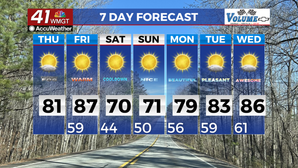
Today


The sun is back for our Friday. Temperatures will top off in the lower 80s around Middle Georgia. Winds will shift from the northeast to the southeast as the day progresses with sustained speeds of 10-15 mph. Gusts could reach speeds of 25 mph. Skies will remain clear during the daylight hours.


The skies will be clear initially as we roll into tonight. After midnight we will see cloud cover increase, especially as the sunrise hours approach. Winds overnight will come from the southeast at 5-10 mph. Temperatures will remain warm, only dropping into the upper 50s and lower 60s ahead of the sunrise. Rain is likely in the northwestern counties of the region heading into the sunrise hours of Saturday.
Tomorrow


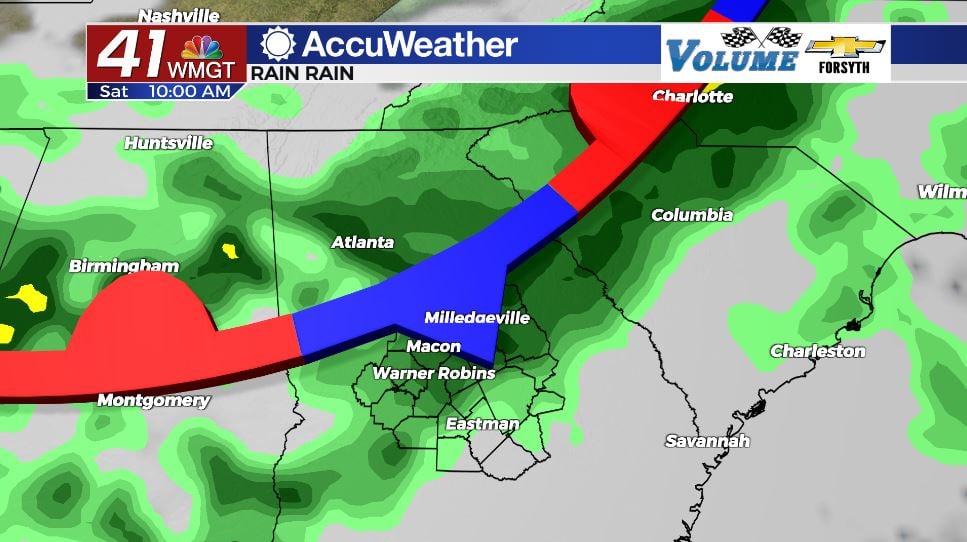
It will be a gloomy one for our Saturday as the sunshine will be limited by an abundance of clouds. It will still be rather warm as highs reach the lower 80s for most of the region. The first half of the day looks to be the rainy half as storms arrive early. As of now the Storm Prediction Center has issued a Level 1 “Marginal” risk for severe weather for all of Middle Georgia tomorrow afternoon. The primary risk will be some strong wind gusts with a couple of storms. Hail and tornadoes are highly unlikely, but cannot be completely ruled out.


Storm activity will begin to subside in the late afternoon hours. The northern counties will likely see a bit of sun as the day comes to a close. Mostly clear conditions will take over across the region overnight, however lows will stay warm, only dropping into the lower 60s. Winds will blow from the west southwest at 2-6 mph.
Easter and Beyond


The forecast for Easter is very similar to the one for tomorrow as highs will reach the upper 70s and lower 80s under mostly cloudy skies. Storms are likely in the afternoon as well, although right now there is not clear agreement on when. This is unfortunate for those planning out door egg hunts for the holiday, as many of these are often planned for the late morning and early afternoon. As of now there isn’t really a severe weather risk, although a portion of Dooly and Wilcox Counties are included in a Level 1 “Marginal” risk. It’s likely just going to be a gross afternoon, but nothing more.

Overnight skies will stay cloudy as a cold front approaches from the west. That cold front could bring some strong to severe storms with it during the early morning hours of Monday. Lows rolling into Monday will again be in the lower 60s as warm air hangs around just ahead of the cold front.

Monday morning will be stormy as a cold front pushes through. After that, skies will clear and a dry pattern will take over. A mix of sun and clouds with highs in the lower 70s and upper 80s can be expected for the back half of next week at this time.

Follow Meteorologist Aaron Lowery on Facebook (Aaron Lowery 41NBC) and Twitter (@ALowWX) for weather updates throughout the day. Also, you can watch his forecasts Monday through Friday on 41NBC News at Daybreak (6-7 a.m.) and 41Today (11 a.m).