


Rain continues tonight; more storms tomorrow
MACON, Georgia (41NBC/WMGT) – Persistent light rain will continue through the evening and tonight around Middle Georgia before slowing and another round of storms is likely Wednesday as well.
This Evening
Overcast skies and widespread rain have been the theme of the day along with well below average temperatures. Overnight will be muggy and also a bit breezy with wind from the southwest at 5-12 mph. Gusts should reach to around 16 mph. The rain should subside by sunrise Wednesday morning. Low temperatures will hover around 70 degrees.
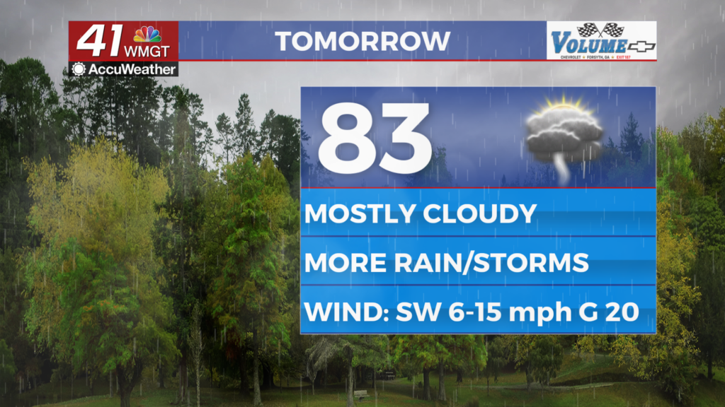
Tomorrow
Another mostly cloudy day is likely Wednesday however without the constant rain temperatures should warm into the low to mid 80s. The afternoon will see several showers and storms with some persisting into the late evening. The wind will continue from the southwest 5-15 mph with gusts reaching 20+ mph.


Overnight early on a few showers or a storm may persist however overnight rain odds will be much lower than Tuesday night. Temperatures will valley in the lower 70s for most of the region as the wind shifts more to out of the south-southwest at 5-10 mph.
Thursday and Beyond
Tropical Depression One has formed in the Gulf and will likely become Tropical Storm Arthur before making landfall on the Louisiana coast sometime Wednesday afternoon/evening. The remnants of this system will move in to Georgia on Thursday bringing heavy rain. Combined with the fronts already in the area a flash flooding threat is likely. There is also a Level 1 “Marginal” threat for severe storms Thursday as well. The primary risk will be a few damaging wind gusts. Hail is unlikely, however a brief spin-up tornado could be possible. Rain odds will remain elevated Friday as well before dropping some into Father’s Day weekend.

Follow Chief Meteorologist Aaron Lowery on Facebook (Aaron Lowery 41NBC) and X (@ALowWX) for weather updates throughout the day. Also, you can watch his forecasts Monday through Friday on 41NBC News at 4, 5, 5:30, 6, and 11 p.m.