
Rain chances return Friday evening
MACON, Georgia (41NBC/WMGT) – An incoming cold front will bring an opportunity for some rain starting Friday evening.
This Evening
A partly cloudy and warm day will give way to a partly cloudy, warm, and muggy night. Lows will be in the upper 50s with the warmest spots possibly staying at or above 60 degrees. Fog will also be possible through the overnight hours as the wind will be very light from the south and moisture content in the air continues to rise. Some fog may be dense. No rain is expected tonight, however.
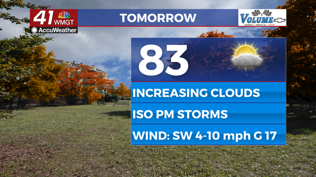
Tomorrow
Friday should begin with a good amount of sunshine however clouds will gradually fill in throughout the day. Highs will reach into the low to mid 80s around the region as breezes pick up from the southwest. Gusts will range from 15-20 mph. Rain is unlikely during the daylight hours however a shower or two could be possible during the suppertime hours.


Overnight will see better odds for rain but even then overall activity will be isolated. For the most part it will be showers however a rumble of thunder or two cannot be ruled out. Low temperatures will be in the mid 60s for most of the region as the wind continues from the southwest-southwest at 5-10 mph. Gusts will still push as high as 20 mph through the night.
This Weekend
Another weekend, another split forecast. Saturday will be the gloomier of the two days as isolated to scattered showers and perhaps a few thunderstorms are likely during the afternoon and evening. Highs will reach into the low to mid 80s around the region under mostly cloudy skies.

Sunday on the other hand will be a sunny day with cooler breezes from the northwest. Highs will only reach the mid to upper 70s Sunday afternoon as the effects of the cold front begin to take hold.

Follow Chief Meteorologist Aaron Lowery on Facebook (Aaron Lowery 41NBC) and X (@ALowWX) for weather updates throughout the day. Also, you can watch his forecasts Monday through Friday on 41NBC News at 4, 5, 5:30, 6, and 11 p.m.