
Rain chances go up for Middle Georgia
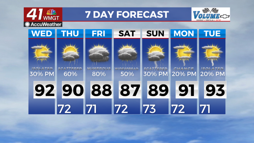
MACON, Georgia (41NBC/WMGT) – Wednesday brings the potential for isolated to scattered storms across most of the area, as well as another day of heat index values ranging from 100 to 105 


degrees for many. Models are at odds regarding when diurnal convection begins and the coverage, but in general, it appears that something of a thermal gradient (temperature change) along a morning cloud deck could act as a focus for storm development— roughly along the southeast of the I-85 corridor. Additionally, these same models show clusters of convection progressing across Mississippi, Tennessee, and Alabama Thursday night, but a clear signal is lacking regarding this convection making it eastward into Georgia. Beginning Thursday, the troughing will be elongated over the eastern U.S. with a push of vorticity (spin) moving into the area throughout the day as the front is over the north Georgia area. Current guidance suggests stalling over the I-85 corridor 


for Thursday. As a result rain chances are in the likely range as showers and thunderstorms are expected during the afternoon and evening hours. Models also show that storms should stay tame but we will watch for any flooding concerns with very little shear in the area when these storms form. With high moisture content and the storms expected to form along the flow this could also increase the flooding threat. Going into Friday, expect similar conditions with the trough still fully over our area. Saturday will begin the pattern change with showers and thunderstorms mostly 

over the southern half of the area and ridging beginning to build in over the Central and Eastern U.S. As a result rain chances begin to decrease Sunday into Tuesday with only 20-30 percent chances during the afternoon. Temperatures will be seasonable in the mid 80s to low 90s across the area through Saturday before beginning to warm slightly into the mid 90s as ridging begins settling in Saturday and Sunday.