Rain chances down but still there for tonight/Saturday morning
MACON, Georgia (41NBC/WMGT) – A weak cold front will bring a few isolated showers and storms to Middle Georgia overnight Friday into Saturday morning.
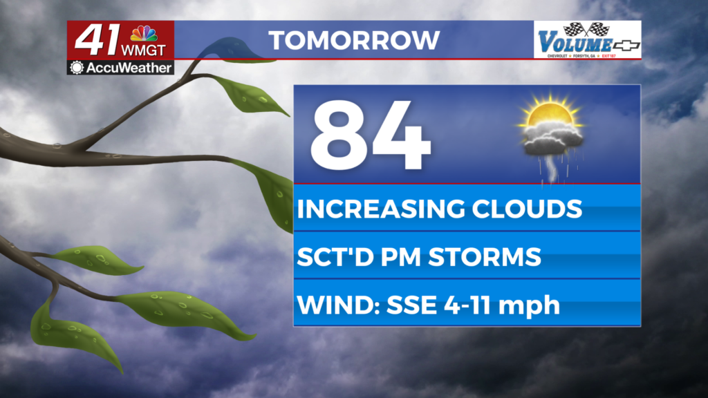
Today
Conditions will remain mostly sunny (cumulus cloud fields are likely heading into lunchtime) for much of the day on Friday before upper level clouds begin to move in during the afternoon. Temperatures will peak in the low to mid 80s with heat indexes in the mid to upper 80s. Winds will blow from the south-southeast throughout the day at about 5-12 mph, however gusts could reach as high as 20 mph. Cloud cover is expected to thicken a bit more as the sun sets this evening.
As for tonight’s rain chances the region likely will not see anything until close to 10 PM. Some showers and isolated storms will be most likely between the hours of midnight and 8 am Saturday morning. Severe weather is not expected, however a couple of storms could have relatively strong wind gusts. Temperatures will bottom out in the lower 60s ahead of the sunrise on Saturday morning. Some showers and an isolated storm may linger into Saturday morning as well.
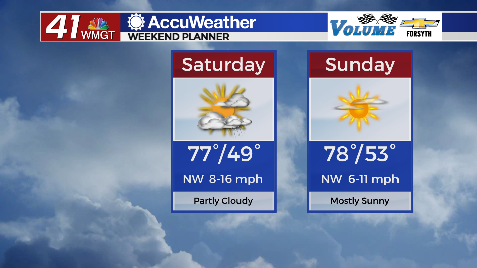
Saturday
There will be a decent amount of cloud cover early along with a couple of isolated showers (maybe even a storm) during the early parts of the morning. These will dissipate during the later morning hours along with some clearing overhead. The incoming cold front is expected to pass through Middle Georgia during the lunchtime hours and will likely arrive with a line of clouds. An isolated storm or two will be possible in the far southeastern counties as temperatures heat up later in the day, however any potential severe storms should be reserved for Southeastern Georgia and the Carolinas.


Most of the afternoon and evening around Middle Georgia will be pleasant as partly sunny skies stick around along with high temperatures in the upper 70s. Winds will be on the breezy side, however, coming in at 10-15 mph and gusting upwards of 25 out of the northwest.


It will still be a little breezy from the north-northwest overnight as the majority of leftover clouds clear out. Temperatures are expected to drop into the lower 50s and upper 40s ahead of Sunday morning.
Sunday and Beyond
Mostly sunny conditions are expected Sunday afternoon with high temperatures again in the upper 70s. Winds will persist out of the northwest at about 5-10 mph (gusting up to about 17 mph). Cloud cover will begin to return in the evening with mostly cloudy skies expected overnight. Temperatures will bottom out in the lower 50s for most of Middle Georgia ahead of Monday morning.
Next week looks to be cooler overall than this week, however this will come with a lot of added cloud cover and some solid rain chances in the middle (and potentially back half) of next week.

Follow Meteorologist Aaron Lowery on Facebook (Aaron Lowery 41NBC) and Twitter (@ALowWX) for weather updates throughout the day. Also, you can watch his forecasts Monday through Friday on 41NBC News at Daybreak (5-7 a.m.) and 41Today (11 a.m).