


Rain chances begin to ramp up
MACON, Georgia. (41NBC/WMGT) – Cloud cover has returned to the Peach State and rain chances will gradually climb.
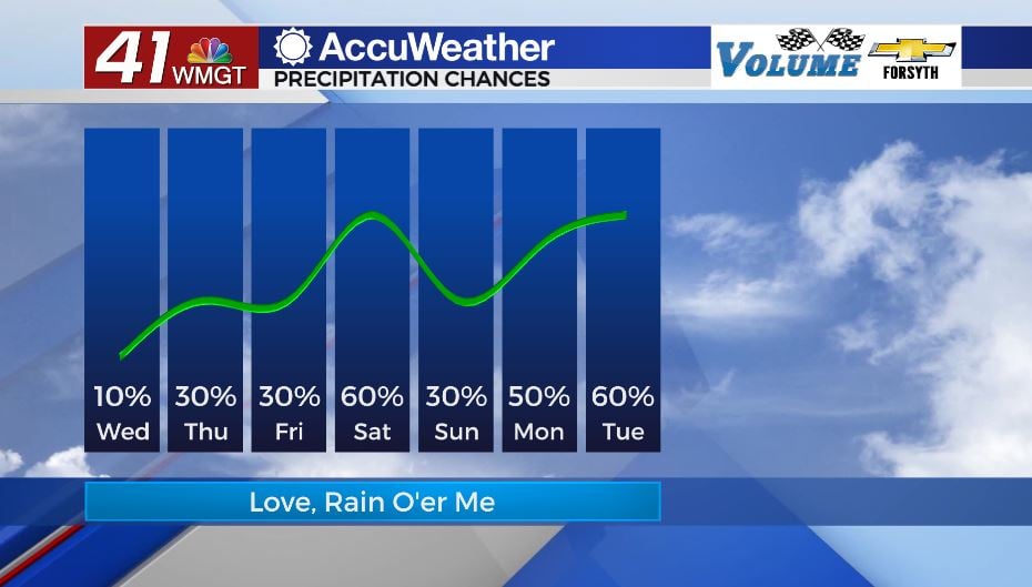
Today
The clouds filled in over much of Georgia overnight, and the sunrise was nowhere to be seen this morning. In response it was a much warmer beginning to our Wednesday with temperatures ranging from the mid 40s into the low 50s. The overcast skies will not remain with us today, however a good amount of clouds will. Highs this afternoon will climb into the mid to upper 60s as winds continue to blow from the east-northeast. Cloud cover will gradually break through the day, allowing more sunshine during the evening. A couple of showers will also be possible early, however most of the region will stay dry. For those that do see rain it will be light and over quickly.


Overnight tonight the cloud cover will return. Shower chances overnight will be extremely low, however one or two strays cannot be ruled out. The wind will shift to the east at around 5-10 mph, finally removing the northern component. Temperatures heading into tomorrow morning will be in the upper 40s and lower 50s thanks to an abundance of cloud cover to insulate the region.
Tomorrow
Thursday will also see its fair share of cloud cover. The day will begin likely under blanket conditions, and throughout the afternoon there will be more clouds than sun. Isolated showers will be possible around Middle Georgia, and while there will be more than Wednesday, there may still be some locations that stay dry. With the wind shifting to the south-southeast at about 5 mph shortly after sunrise, temperatures will climb into the upper 60s and lower 70s despite the abundance of cloud cover.

Overnight cloud cover will remain abundant as the wind continues to blow out of the south-southeast. Low temperatures around the region will fall into the lower to mid 50s, about 20 degrees warmer than just two days prior. Shower chances will drop overnight, but a stray or two cannot be ruled out.
Friday
Friday is when rain chances begin to climb a bit higher. Most of Middle GA will likely see some shower activity during the afternoon. The wind will shift to the south at around 5 mph early on as temperatures around the region reach the mid to upper 70s. There will again be an abundance of cloud cover as well as the next system approaches from the west. The cold front with the system will stall out over Tennessee, however, largely due to a stubborn ridging pattern over the Atlantic. This will limit our rain chances to scattered showers on Friday, though a rumble of thunder cannot be ruled out.
The Weekend
Saturday a next system will advance in from the west, and the ridge will finally weaken. This will allow the stationary front to become a cold front once again, and it will bring moderate to heavy rain to Georgia with some thunder. It’s too far out to tell right now, but severe weather doesn’t look overly likely with the coming system (at least not in GA). Southwest winds at 10+ mph will allow more warmth to make its way into Georgia, warming our highs into the upper 70s around the region. A couple of spots could eclipse 80 degrees.
The cold front will have passed by Sunday, however the skies will do anything but clear in its wake. Cloud cover will remain abundant and scattered showers will remain possible during the afternoon hours. The wind will mainly blow from the north-northwest, but it will be shifting more eastward as the day progresses, especially late. High temperatures will drop back into the mid to upper 60s as a cooling trend begins heading into next week.

Follow Meteorologist Aaron Lowery on Facebook (Aaron Lowery 41NBC) and Twitter (@ALowWX) for weather updates throughout the day. Also, you can watch his forecasts Monday through Friday on 41NBC News at Daybreak (6-7 a.m.) and 41Today (11 a.m).

Leave a Reply