Rain and thunderstorm odds begin to increase tonight and tomorrow
MACON, Georgia (41NBC/WMGT) – The slow moving cold front is arriving in Georgia tonight, increasing the rain odds for Middle Georgia as the weekend nears.
The Rest of the Evening


Mostly cloudy skies will remain with Middle Georgia as a few isolated showers and perhaps a thunderstorm occur within the region. It will remain very warm and humid with low temperatures only dropping into the low to mid 60s. Winds will come from the south-southwest at about 5-10 mph, so some patchy fog will also be possible along with any showers.
Tomorrow


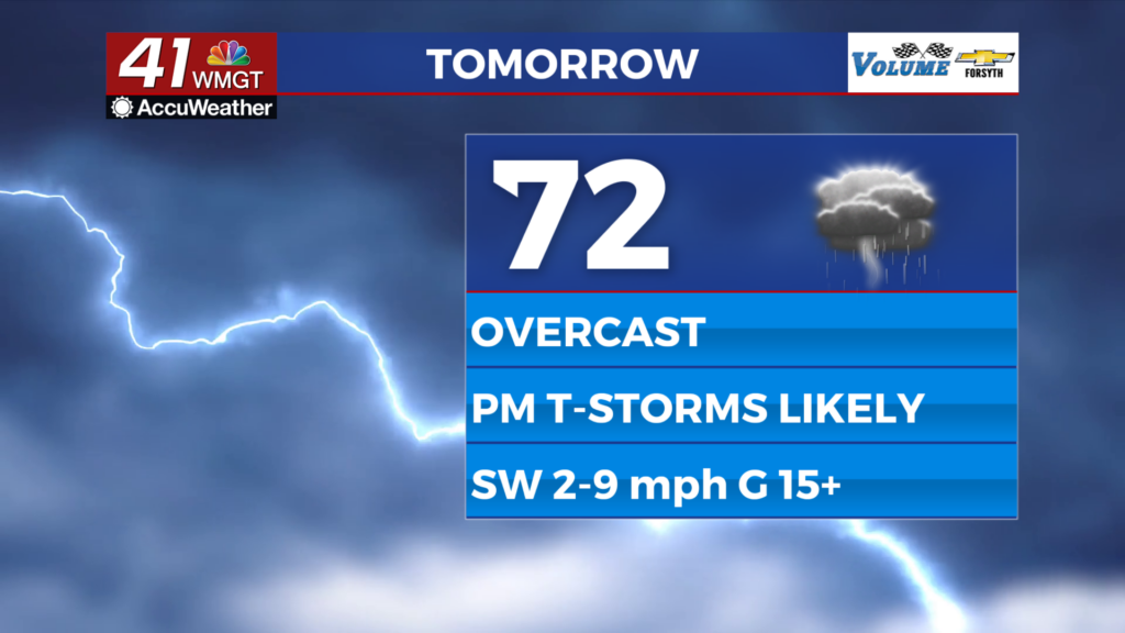
Early on Friday skies will largely be overcast with the possibility for a few isolated showers. Thunderstorm odds will begin to increase during the later part of the afternoon as the cold front approaches the region but begins to stall out. The northern half of Middle Georgia will have the best odds for thunderstorms tomorrow, however they can occur anywhere. Highs will reach into the low to mid 70s with wind from the southwest coming in at around 5 mph.


No severe weather is expected, however the Flood Watch to the north has been expanded and now includes Upson, Lamar, Butts, and Jasper Counties. This is set to expire at 7:00 PM Saturday.


Thunderstorms will turn to showers during the late evening and overnight as the cold front stalls and becomes a stationary front. This will eventually turn into a warm front Saturday morning. Winds will come from the south at around 5 mph with low temperatures again staying warm in the lower 60s.
The Weekend


Saturday will be off to a cloudy start with perhaps a few showers as the stationary front becomes a warm front and begins to track northeast. Temperatures will climb into the mid to upper 70s during the afternoon ahead of a cold front that will arrive in the evening. Ambient winds will largely come from the south-southwest at about 20 mph with gusts potentially pushing over 30 mph.


Thunderstorms and showers are likely in the evening as the cold front comes through. A Level 1 “Marginal” threat for severe weather currently includes Upson, Taylor, Lamar, Butts, Crawford, Macon, Peach, and Monroe Counties along with Western Bibb, Jones, and Jasper Counties. The primary risk will be a few strong wind gusts (along with any flash flood potential), though a brief tornado cannot be ruled out. Skies overnight will remain cloudy, however the passing cold front will drop temperatures into the upper 40s ahead of Sunday morning.

Sunday will be nicer in regards to rainfall (none is expected), however mostly cloudy skies will linger with afternoon highs only reaching into the low to mid 50s. Overnight it will be colder as lows dip into the upper 30s. Sunny skies should return Monday.

Follow Meteorologist Aaron Lowery on Facebook (Aaron Lowery 41NBC) and Twitter (@ALowWX) for weather updates throughout the day. Also, you can watch his forecasts Monday through Friday on 41NBC News at 4, 5, 5:30, 6, and 11 p.m.