One more dry day before impactful weather arrives
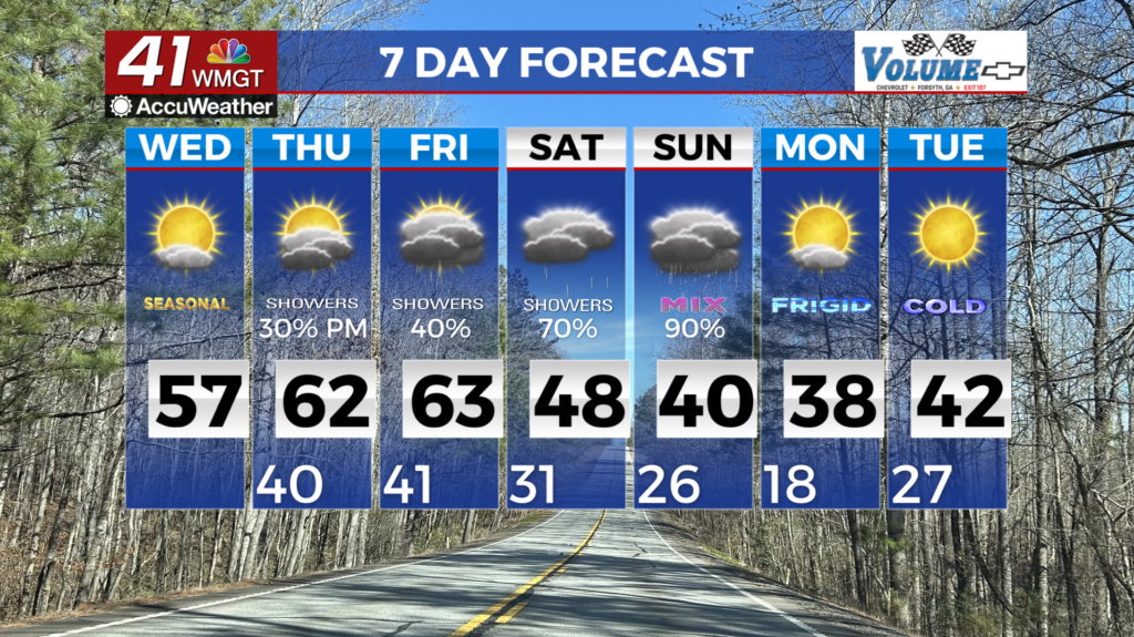
MACON, Georgia (41NBC/WMGT) – We are expecting near-normal high temperatures today, with highs near 60 degrees. High pressure is in control as lighter winds are expected, out of the 


east during the morning, becoming southeast to southwest during the afternoon. Thursday begins our very active and potentially high impact weekend of weather for north and Middle Georgia. Thursday into Friday we will have our first wave of rainfall as a quick shortwave pushes through the main trough over the eastern U.S. Moving ahead into the main scenario of weather that is shaping up this weekend, there’s quite a bit to discuss. Saturday into Sunday we begin to see the overall pattern begin to dive south into the region while the low pressure system currently off the Pacific begins to push inward. The timing of how this low pressure moves is going to in turn factor into how long we are going to experience potential impacts. Here are some takeaways with this event. This is shaping up to be a potentially historic event with moderate to major impacts. Our models are beginning to gain confidence and consistency in the overall scheme, that this could be a long duration event as well, with the possibility of initiation as early as Saturday afternoon with wintry precipitation extending into Sunday evening and possibly in Monday. At this point we are confident that wintry precip will affect North Georgia in the areas north of I-20. The area south of I-20 to Macon and Columbus are a little more uncertain but models are consistently forecasting wintry mix as well for these areas. A few factors could influence how much and what type precipitation we receive are 1) the influence of the cold air wedge (cold air banked up against the mountains) 2) how far north the front pushes. When it comes to the wedge, the models are having a tough time resolving the wedge. Current thinking is that snow will be the main precipitation type for far north Georgia and wintry mix/freezing rain will be the main concern for the remainder of the region. There is still the possibility that we see freezing rain change over to more of a snow event as we get into late Sunday, however that is a bit more uncertain. The main takeaway is we want you to focus on being prepared for this potentially high impact event this weekend. There will likely be more changes in the coming days but please make sure you have a plan in place should you lose power.