


One day of rain down, several more to go
MACON, Georgia. (41NBC/WMGT)-Rain chances will remain high through the weekend as the remains of Nicholas stall out.
Today
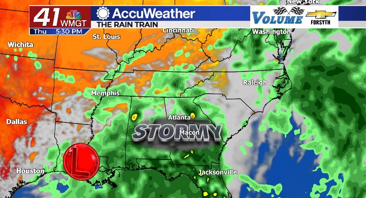
Rain fell throughout much of the night across Middle Georgia, continuing into the early hours of this morning. Rainwater was beginning to pool already in some low-lying areas, posing hazards to low riding vehicles. We will receive plenty more rain around the region this afternoon as cloudy skies remain. Temperatures will remain cool, and the diurnal temperature range will be smaller than usual. High temperatures for this afternoon will be hanging around the mid 70s; only a few degrees warmer than the upper 60s and low 70s to kick off the morning.
The steady rainfall is expected to slow during the lunchtime hours. Quickly following that, however, scattered thunderstorm activity will fire up for the late afternoon and evening hours. The good news is that rainfall is not expected to be consistent overnight. A few isolated thunderstorms will be possible, but overnight rain totals will be a lot less than last night. Still, most of Middle Georgia will receive more than 1/2 inch of rainfall over the next 24 hours. A few locations will receive more than an inch.
Tomorrow
Friday morning will kick off cloudy, however widespread rain is not expected out the door at this time. A few pockets of sunshine may form during the early afternoon hours, but scattered showers and storms will follow during the late afternoon and evening hours. High temperatures will also return to the upper 70s and lower 80s around the region as a slow rebound begins following the cold front. The afternoon storms will carry into the evening and overnight hours bringing some localized heavy rainfall to some locations in Middle GA. The majority of these will fizzle out before midnight with low temperatures falling to the lower 70s and upper 60s.
The Weekend and Early Next Week
A pair of relatively cloudy days will fill up our coming weekend, breaking the trend of a wet midweek and a dry and pleasant weekend. Scattered storms are likely to form during the afternoon hours on both Saturday and Sunday, still keeping things relatively cool. Highs this weekend will hover about in the low 80s while low temperatures overnight drop into the lower 70s and upper 60s. The good news is that heading into the start of next week low temperatures will drop a bit each night, signaling an upcoming drop in humidity. All the while high temperatures will slowly climb back up into the mid 80s as the sun fights its way back into our skies. At this time, however, rain remains possible through at least next Wednesday for most of the Peach State.

Follow Meteorologist Aaron Lowery on Facebook (Aaron Lowery 41NBC) and Twitter (@ALowWX) for weather updates throughout the day. Also, you can watch his forecasts Monday through Friday on 41NBC News at Daybreak (6-7 a.m.) and 41Today (11 a.m).


Leave a Reply